IMAGES TAKEN NEAR TO
Kirkintilloch, GLASGOW, G66 3TG
Introduction
This page details the photographs taken nearby to G66 3TG by members of the Geograph project.
The Geograph project started in 2005 with the aim of publishing, organising and preserving representative images for every square kilometre of Great Britain, Ireland and the Isle of Man.

There are currently over 7.5m images from over14,400 individuals and you can help contribute to the project by visiting https://www.geograph.org.uk
Image Map
Images are licensed for reuse under creativecommons.org/licenses/by-sa/2.0
Notes
- Clicking on the map will re-center to the selected point.
- The higher the marker number, the further away the image location is from the centre of the postcode.
Image Listing (7 Images Found)
Images are licensed for reuse under creativecommons.org/licenses/by-sa/2.0
Image
Details
Distance
1
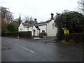
House on the B8048
At the bottom of Easterton Farm Road.
Image: © Stephen Sweeney
Taken: 20 Dec 2011
0.01 miles
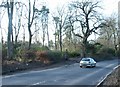
2

Wester Gartshore East Lodge
On the B8048 east of Kirkintilloch.
Image: © G Laird
Taken: 24 Jun 2012
0.03 miles

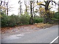
4
Eastern gateway to Wester Gartshore
Eastern gateway to Wester Gartshore House from the B8048
Image: © Jim Bain
Taken: 26 Feb 2006
0.15 miles
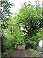
5
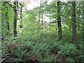
Woodland, Gartshore
The ferns are now out and soon the woods will be dark beneath the canopy.
Image: © Richard Webb
Taken: 1 Jun 2012
0.20 miles