IMAGES TAKEN NEAR TO
Lint Mill Road, GLASGOW, G66 3TF
Introduction
This page details the photographs taken nearby to Lint Mill Road, G66 3TF by members of the Geograph project.
The Geograph project started in 2005 with the aim of publishing, organising and preserving representative images for every square kilometre of Great Britain, Ireland and the Isle of Man.

There are currently over 7.5m images from over14,400 individuals and you can help contribute to the project by visiting https://www.geograph.org.uk
Image Map
Images are licensed for reuse under creativecommons.org/licenses/by-sa/2.0
Notes
- Clicking on the map will re-center to the selected point.
- The higher the marker number, the further away the image location is from the centre of the postcode.
Image Listing (23 Images Found)
Images are licensed for reuse under creativecommons.org/licenses/by-sa/2.0
Image
Details
Distance
1
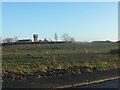
Fauldhead from the west
The water tower is clearly visible.
Image: © Stephen Sweeney
Taken: 15 Dec 2011
0.09 miles
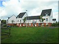
3

New houses
The houses are part of a recent development adjacent to Market Road. In the foreground the rosebay willowherb is going to seed.
Image: © Richard Sutcliffe
Taken: 18 Sep 2020
0.12 miles

5
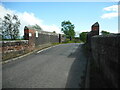
Calfmuir Road bridge
Road bridge over the railway (EGM1/104).
Image: © Richard Sutcliffe
Taken: 10 May 2022
0.14 miles
6
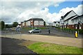
Roundabout on Calfmuir Road
Roundabout at junction of Calfmuir Road (straight on) with Menzies Drive to the left and Farm Wynd to the right.
Image: © Richard Sutcliffe
Taken: 10 May 2022
0.15 miles
7
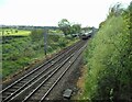
Railway Line
The Glasgow to Edinburgh line, seen from Calfmuir Road bridge.
Image: © Richard Sutcliffe
Taken: 10 May 2022
0.16 miles
8
Kirkintilloch, Market Road
On the southern outskirts of the town looking north towards the Campsie Fells.
Image: © Robert Murray
Taken: 8 Nov 2009
0.17 miles
9

Gas connection
This rusty connector has a plate on the side which states it is a Megga-gaZ model 3 MG 180 QR, but I have no idea what its function may be. It is situated at the back of the verge at the junction of Calfmuir Road and Ninian Crescent.
Image: © Richard Sutcliffe
Taken: 18 Sep 2020
0.17 miles
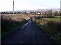
10

Calfmuir Road
Calfmuir Road used to be a quiet country road until a large number of houses were built in the area in recent years and the road was upgraded.
Image: © Richard Sutcliffe
Taken: 18 Sep 2020
0.17 miles