IMAGES TAKEN NEAR TO
Kirkintilloch, GLASGOW, G66 3TD
Introduction
This page details the photographs taken nearby to G66 3TD by members of the Geograph project.
The Geograph project started in 2005 with the aim of publishing, organising and preserving representative images for every square kilometre of Great Britain, Ireland and the Isle of Man.

There are currently over 7.5m images from over14,400 individuals and you can help contribute to the project by visiting https://www.geograph.org.uk
Image Map
Images are licensed for reuse under creativecommons.org/licenses/by-sa/2.0
Notes
- Clicking on the map will re-center to the selected point.
- The higher the marker number, the further away the image location is from the centre of the postcode.
Image Listing (24 Images Found)
Images are licensed for reuse under creativecommons.org/licenses/by-sa/2.0
Image
Details
Distance
1
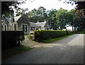
Wester Gartshore Cottages
Estate cottages.
Image: © Richard Sutcliffe
Taken: 18 Sep 2020
0.01 miles
2
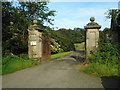
Lodge gates
These grand gate piers and metal gates are at the former Gartshore House's West Lodge (just visible on the right). Gartshore House itself was demolished is 1955.
Image: © Richard Sutcliffe
Taken: 18 Sep 2020
0.02 miles
3
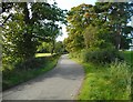
Road southeast of Wester Gartshore
Image: © Richard Sutcliffe
Taken: 18 Sep 2020
0.05 miles
4
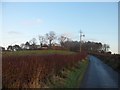
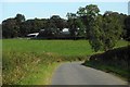
Approaching Wester Gartshore
From the west.
Image: © Stephen Sweeney
Taken: 15 Dec 2011
0.06 miles
5
![Gartshore Estate [9]](https://s2.geograph.org.uk/geophotos/03/30/10/3301018_98ed76ab_120x120.jpg)
Gartshore Estate [9]
View across farmland towards the Campsie Fells.
Image: © Robert Murray
Taken: 5 Jan 2013
0.07 miles
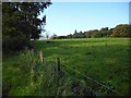
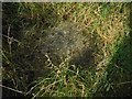
7
Gravestone, Quakers' Cemetery
The gravestone is just visible above the vegetation which is taking over the cemetery. It is inscribed "BEDCOW" with a "G" above the "W".
The burial ground consists of a stone wall enclosure containing some old headstones. It was given by Robert Smailly, of Wester Gartshore in 1674 as a "burial place for the friends of the Truth". It is Category B listed http://portal.historicenvironment.scot/designation/LB12720.
In the distance is Waterside Bing, a reminder of the former Wester Gartshore Colliery.
Image: © Richard Sutcliffe
Taken: 18 Sep 2020
0.08 miles
8
Wester Gartshore
The farm buildings are obscured by the surrounding trees.
Image: © Richard Sutcliffe
Taken: 18 Sep 2020
0.09 miles
9
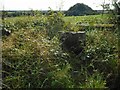
Entrance to the Quakers' Cemetery
The burial ground consists of a stone wall enclosure containing some old headstones. It was given by Robert Smailly, of Wester Gartshore in 1674 as a "burial place for the friends of the Truth". It is Category B listed http://portal.historicenvironment.scot/designation/LB12720.
Image: © Richard Sutcliffe
Taken: 18 Sep 2020
0.09 miles
10
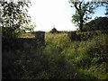
Fallen headstone
In the Quakers' Cemetery at Wester Gartshore. It is inscribed:
W G
WESTER MUCKROFT
1803
The burial ground consists of a stone wall enclosure containing some old headstones. It was given by Robert Smailly, of Wester Gartshore in 1674 as a "burial place for the friends of the Truth". It is Category B listed http://portal.historicenvironment.scot/designation/LB12720.
Image: © Richard Sutcliffe
Taken: 18 Sep 2020
0.09 miles