IMAGES TAKEN NEAR TO
Woodstock Avenue, GLASGOW, G66 3RS
Introduction
This page details the photographs taken nearby to Woodstock Avenue, G66 3RS by members of the Geograph project.
The Geograph project started in 2005 with the aim of publishing, organising and preserving representative images for every square kilometre of Great Britain, Ireland and the Isle of Man.

There are currently over 7.5m images from over14,400 individuals and you can help contribute to the project by visiting https://www.geograph.org.uk
Image Map
Images are licensed for reuse under creativecommons.org/licenses/by-sa/2.0
Notes
- Clicking on the map will re-center to the selected point.
- The higher the marker number, the further away the image location is from the centre of the postcode.
Image Listing (7 Images Found)
Images are licensed for reuse under creativecommons.org/licenses/by-sa/2.0
Image
Details
Distance
1

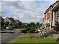
Rosebank, Kirkintilloch
Housing estates and, the open area lower centre, the Merklands Nature Reserve.
Image: © M J Richardson
Taken: 9 Feb 2015
0.14 miles
2
Briar Road, Kirkintilloch, East Dunbartonshire
A 1960's development of private housing on the Eastern edge of Kirkintilloch
Image: © Brian D Osborne
Taken: 8 Sep 2005
0.15 miles
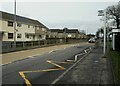
3
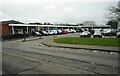
Local shops
A selection of small shops down two sides of a square, off Merkland Drive.
Image: © Richard Sutcliffe
Taken: 25 Feb 2022
0.18 miles
4
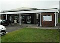
The Chase Inn
Public bar beside the shops off Merkland Place.
Image: © Richard Sutcliffe
Taken: 25 Feb 2022
0.20 miles
5
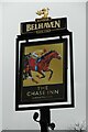
Sign for The Chase Inn
Public bar in Kirkintilloch Image
Image: © Richard Sutcliffe
Taken: 25 Feb 2022
0.20 miles
7
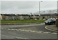
Junction of Alloway Drive and Langmuir Road
A 'Kids Playzone' is in part of the open space beyond.
Image: © Richard Sutcliffe
Taken: 25 Feb 2022
0.22 miles