IMAGES TAKEN NEAR TO
Iona Way, GLASGOW, G66 3QA
Introduction
This page details the photographs taken nearby to Iona Way, G66 3QA by members of the Geograph project.
The Geograph project started in 2005 with the aim of publishing, organising and preserving representative images for every square kilometre of Great Britain, Ireland and the Isle of Man.

There are currently over 7.5m images from over14,400 individuals and you can help contribute to the project by visiting https://www.geograph.org.uk
Image Map
Images are licensed for reuse under creativecommons.org/licenses/by-sa/2.0
Notes
- Clicking on the map will re-center to the selected point.
- The higher the marker number, the further away the image location is from the centre of the postcode.
Image Listing (12 Images Found)
Images are licensed for reuse under creativecommons.org/licenses/by-sa/2.0
Image
Details
Distance
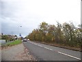
2
Farmland east of Harestanes, Kirkintilloch
Looking to Braes of Yetts.
Image: © Stephen Sweeney
Taken: 12 Aug 2010
0.17 miles
3
Applecross Road
In Harestanes, Kirkintilloch.
Image: © Stephen Sweeney
Taken: 12 Aug 2010
0.18 miles
4
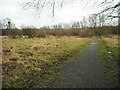
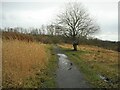
Path in Merkland Nature Reserve
One of a series of paths through the Local Nature Reserve area.
Image: © Richard Sutcliffe
Taken: 25 Feb 2022
0.19 miles
5
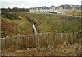
The Black Burn
With new houses on the northern side.
Image: © Richard Sutcliffe
Taken: 25 Feb 2022
0.19 miles
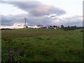
6
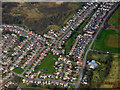
Rosebank from the air
Rosebank is a suburb of Kirkintilloch.
Image: © Thomas Nugent
Taken: 7 Apr 2016
0.21 miles
7
Dog tree
Some owners have fastened mementos of their former dogs Image onto this tree in Merkland Local Nature Reserve.
Image: © Richard Sutcliffe
Taken: 25 Feb 2022
0.21 miles
8
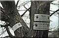
Canine memorials
Some owners have fastened reminders of their dogs onto this tree Image
Image: © Richard Sutcliffe
Taken: 25 Feb 2022
0.21 miles
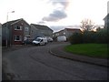
9
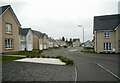
Rotary Way
New housing on the outskirts of Kirkintilloch.
Image: © Richard Sutcliffe
Taken: 25 Feb 2022
0.21 miles
10
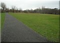
Playing field
Beside Merklands Local Nature Reserve.
Image: © Richard Sutcliffe
Taken: 25 Feb 2022
0.24 miles