IMAGES TAKEN NEAR TO
Cottongrass Court, GLASGOW, G66 3NY
Introduction
This page details the photographs taken nearby to Cottongrass Court, G66 3NY by members of the Geograph project.
The Geograph project started in 2005 with the aim of publishing, organising and preserving representative images for every square kilometre of Great Britain, Ireland and the Isle of Man.

There are currently over 7.5m images from over14,400 individuals and you can help contribute to the project by visiting https://www.geograph.org.uk
Image Map
Images are licensed for reuse under creativecommons.org/licenses/by-sa/2.0
Notes
- Clicking on the map will re-center to the selected point.
- The higher the marker number, the further away the image location is from the centre of the postcode.
Image Listing (25 Images Found)
Images are licensed for reuse under creativecommons.org/licenses/by-sa/2.0
Image
Details
Distance
1
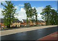
View from Menzies Drive
Looking onto the backs of properties on Linnet Drive, which are slightly lower than Menzies Drive.
Image: © Richard Sutcliffe
Taken: 10 May 2022
0.05 miles
3
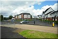
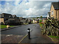
Roundabout on Calfmuir Road
Roundabout at junction of Calfmuir Road (straight on) with Menzies Drive to the left and Farm Wynd to the right.
Image: © Richard Sutcliffe
Taken: 10 May 2022
0.08 miles
4
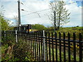
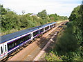
A passing train
British Rail Class 385 No. 385 114 on the Glasgow to Edinburgh line. A strong metal fence prevents access onto the railway.
Image: © Richard Sutcliffe
Taken: 10 May 2022
0.09 miles
5
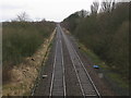
Railway Line east of Lenzie
A long straight section of the Croy line between Lenzie and Croy railway stations viewed from Calfmuir Road.
Image: © G Laird
Taken: 1 Jan 2014
0.09 miles

7
Glasgow to Edinburgh main line from Calfmuir Road Bridge, near Kirkintilloch
The 1500 hrs train from Glasgow Queen Street to Waverley was conveniently passing. In the background is a water tower for the former Woodilee Hospital
Image: © Brian D Osborne
Taken: 12 Sep 2005
0.10 miles
8
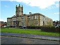
Clock Tower Court
Now private residential accommodation, this was the main block of the former Woodilee Hospital (originally known as the Barony Lunatic Asylum). Built 1871-75, it closed in 2000. It is Category B listed http://portal.historicenvironment.scot/designation/LB13075.
Image: © Richard Sutcliffe
Taken: 10 May 2022
0.11 miles
9
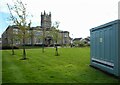
Clock Tower Court
Now private residential accommodation, this was the main block of the former Woodilee Hospital (originally known as the Barony Lunatic Asylum). Built 1871-75, it closed in 2000. It is Category B listed http://portal.historicenvironment.scot/designation/LB13075.
The electricity substation on the right has the notice: 'Clock Tower Court Private Grounds - Keep off grass'.
Image: © Richard Sutcliffe
Taken: 10 May 2022
0.11 miles
10
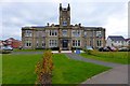
Clocktower building, Woodilee
Originally there was a tower each side flanking the clocktower. A Category B Listed Building. This contributor's mother was a nurse in this hospital during the war (1939-45). For further information see http://homepage.ntlworld.com/sjay.macl/Strathkelvin/woodilee.htm
Image: © Robert Murray
Taken: 3 Oct 2015
0.11 miles