IMAGES TAKEN NEAR TO
Old Duntiblae Road, GLASGOW, G66 3LG
Introduction
This page details the photographs taken nearby to Old Duntiblae Road, G66 3LG by members of the Geograph project.
The Geograph project started in 2005 with the aim of publishing, organising and preserving representative images for every square kilometre of Great Britain, Ireland and the Isle of Man.

There are currently over 7.5m images from over14,400 individuals and you can help contribute to the project by visiting https://www.geograph.org.uk
Image Map
Images are licensed for reuse under creativecommons.org/licenses/by-sa/2.0
Notes
- Clicking on the map will re-center to the selected point.
- The higher the marker number, the further away the image location is from the centre of the postcode.
Image Listing (19 Images Found)
Images are licensed for reuse under creativecommons.org/licenses/by-sa/2.0
Image
Details
Distance
1
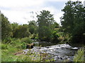
River Luggie at Waterside, near Kirkintilloch
Waterside is a small village, formerly a centre of weaving, on the outskirts of Kirkintilloch
Image: © Brian D Osborne
Taken: 18 Sep 2005
0.04 miles
2
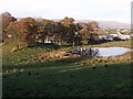
The Mound and the Pond
At the hamlet of Duntiblae near Waterside.
Image: © Robert Murray
Taken: 8 Nov 2009
0.06 miles
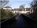
3
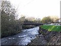
Waterside, footbridge over the Luggie
This is a fairly modern bridge over the river at Waterside and one pier of the previous bridge is still in place.
Image: © Robert Murray
Taken: 8 Nov 2009
0.06 miles
5
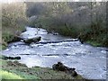
Waterside, Luggie Water ford
The river in spate rushing over the old ford at Waterside. The ford was still in use in the 1960s but seems to have been closed since then.
Image: © Robert Murray
Taken: 8 Nov 2009
0.09 miles
6
Waterside Cottages
Probably upgraded weaver's cottages. As weaving in the village waned coal mining took over as the engine of the village economy.
Image: © Robert Murray
Taken: 8 Nov 2009
0.09 miles
7
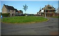
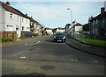
Roundabout, Waterside
The road ahead is Gray Street.
Image: © Richard Sutcliffe
Taken: 18 Sep 2020
0.10 miles
9
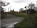
Duntiblae
Unsealed road on the edge of Kirkintilloch.
Image: © Richard Webb
Taken: 14 Oct 2011
0.18 miles
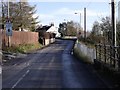
10
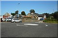
Roundabout at Duntiblae
The old building nearest the roundabout was a smithy according to old maps.
Image: © Richard Sutcliffe
Taken: 18 Sep 2020
0.18 miles