IMAGES TAKEN NEAR TO
Braes O Yetts Drive, GLASGOW, G66 3FF
Introduction
This page details the photographs taken nearby to Braes O Yetts Drive, G66 3FF by members of the Geograph project.
The Geograph project started in 2005 with the aim of publishing, organising and preserving representative images for every square kilometre of Great Britain, Ireland and the Isle of Man.

There are currently over 7.5m images from over14,400 individuals and you can help contribute to the project by visiting https://www.geograph.org.uk
Image Map
Images are licensed for reuse under creativecommons.org/licenses/by-sa/2.0
Notes
- Clicking on the map will re-center to the selected point.
- The higher the marker number, the further away the image location is from the centre of the postcode.
Image Listing (15 Images Found)
Images are licensed for reuse under creativecommons.org/licenses/by-sa/2.0
Image
Details
Distance
1
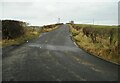
Langmuir Road
Looking up the hill towards a communications mast.
Image: © Richard Sutcliffe
Taken: 25 Feb 2022
0.03 miles
2
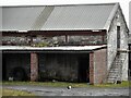
Farm cat
Beside the barn at Braes O' Yetts farm.
Image: © Richard Sutcliffe
Taken: 25 Feb 2022
0.05 miles
3
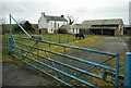
Braes O' Yetts farm
Complete with Shetland pony.
Image: © Richard Sutcliffe
Taken: 25 Feb 2022
0.06 miles
4
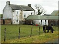
Farmhouse, Braes O' Yetts farm
Complete with Shetland pony.
Image: © Richard Sutcliffe
Taken: 25 Feb 2022
0.06 miles
5
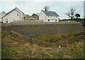
Reataining wall
A high retaining wall above the Black Burn, with new houses on Broadyetts Drive. Braes of Yetts farm is visible behind.
Image: © Richard Sutcliffe
Taken: 25 Feb 2022
0.08 miles
6

Braes of Yetts Farm, near Kirkintilloch
On the eastern outskirts of Kirkintilloch, East Dunbartonshire
Image: © Brian D Osborne
Taken: 8 Sep 2005
0.09 miles
7
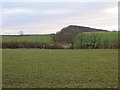
Braes of Yetts
Grass field between roads with a bing in the background from coal mining.
Image: © Richard Webb
Taken: 19 Jan 2014
0.10 miles
8

Entering Kirkintilloch from the East
Along the B8048.
Image: © G Laird
Taken: 24 Jun 2012
0.12 miles
9
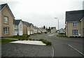
Rotary Way
New housing on the outskirts of Kirkintilloch.
Image: © Richard Sutcliffe
Taken: 25 Feb 2022
0.14 miles
10
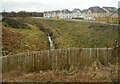
The Black Burn
With new houses on the northern side.
Image: © Richard Sutcliffe
Taken: 25 Feb 2022
0.14 miles