IMAGES TAKEN NEAR TO
Loch Road, GLASGOW, G66 3EN
Introduction
This page details the photographs taken nearby to Loch Road, G66 3EN by members of the Geograph project.
The Geograph project started in 2005 with the aim of publishing, organising and preserving representative images for every square kilometre of Great Britain, Ireland and the Isle of Man.

There are currently over 7.5m images from over14,400 individuals and you can help contribute to the project by visiting https://www.geograph.org.uk
Image Map
Images are licensed for reuse under creativecommons.org/licenses/by-sa/2.0
Notes
- Clicking on the map will re-center to the selected point.
- The higher the marker number, the further away the image location is from the centre of the postcode.
Image Listing (29 Images Found)
Images are licensed for reuse under creativecommons.org/licenses/by-sa/2.0
Image
Details
Distance
2
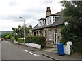
Woodhead Avenue
Neat and distinctive houses at the northern end of Woodhead Avenue. I was born in the further of this pair of semi-detached houses late in 1956, and there is little outward sign of change since that time apart from hedges and trees.
Image: © Jonathan Wilkins
Taken: 23 Jul 2016
0.07 miles
4
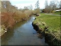
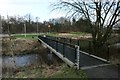
Luggie Water
Looking southeast from the footbridge Image The river divides here, forming a small island.
Image: © Richard Sutcliffe
Taken: 15 Jan 2020
0.14 miles
5
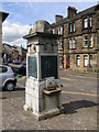
Dalrymple Memorial, Townhead, Kirkintilloch
This memorial is located in Industry Street, and is in memory of the Dalrymples, and erected in 1905. The inscription reads; "Presented to the town of Kirkintilloch by James D G Dalrymple of Woodhead. Senior Magistrate of the burgh of Barony of Kirkintilloch. 1905".
Whilst it might seem a good idea of self publicity, it is highly unlikely whether anyone would tolerate the self publicity of 'gifting' a memorial to yourself in your local town, but perhaps magistrates were held in higher regard then. On the other faces of the memorial are listed all the male members of the Dalrymple bloodline from the 1700's.
Image: © Raymond Okonski
Taken: 15 May 2007
0.15 miles
6
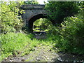
Back o' Loch Halt, Kirkintilloch
Picture taken from the trackbed, looking south to Lenzie, this was Kirkintilloch's rail connection to the outside world, and through the arch was one of Kirkintilloch's TWO railway stations, this halt - "Back o' Loch", and the main station for the town was 0.75km further north. The line left the main Glasgow to Edinburgh route just east of Lenzie station, and headed northwards to Kirkintilloch and the Campsie valley (Lennoxtown, Strathblane & Blanefield). A junction at Whitegates provided a spur to the Forth & Clyde canal for the shipment of coal at Middlemuir Basin (now infilled).
The bridge is scheduled for demolition as it is in the way of the new Kirkintilloch 'Link Road' which will use much of the railway's southern alignment to Lenzie and onwards to an extended M80 motorway at Muirhead.
Image: © Raymond Okonski
Taken: 15 May 2007
0.16 miles
8
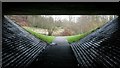
View through the underpass
Looking from one side of the underpass under the A806 to the view on the other side.
Image: © Richard Sutcliffe
Taken: 15 Jan 2020
0.17 miles
10

Roundabout on the A806
Seen from Waterside Road.
Image: © Richard Sutcliffe
Taken: 15 Jan 2020
0.18 miles