IMAGES TAKEN NEAR TO
Lammermoor Place, GLASGOW, G66 3DQ
Introduction
This page details the photographs taken nearby to Lammermoor Place, G66 3DQ by members of the Geograph project.
The Geograph project started in 2005 with the aim of publishing, organising and preserving representative images for every square kilometre of Great Britain, Ireland and the Isle of Man.

There are currently over 7.5m images from over14,400 individuals and you can help contribute to the project by visiting https://www.geograph.org.uk
Image Map
Images are licensed for reuse under creativecommons.org/licenses/by-sa/2.0
Notes
- Clicking on the map will re-center to the selected point.
- The higher the marker number, the further away the image location is from the centre of the postcode.
Image Listing (4 Images Found)
Images are licensed for reuse under creativecommons.org/licenses/by-sa/2.0
Image
Details
Distance
1
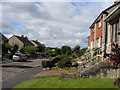
Briar Road, Kirkintilloch, East Dunbartonshire
A 1960's development of private housing on the Eastern edge of Kirkintilloch
Image: © Brian D Osborne
Taken: 8 Sep 2005
0.17 miles
2
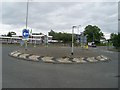
Oxgang Roundabout
In the east of Kirkintilloch.
Image: © Stephen Sweeney
Taken: 4 Sep 2009
0.23 miles
4
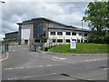
Kirkintilloch High School
A new building opened to the pupils on 19th August 2009, replacing the thirty six year old school on its existing site.
Image: © G Laird
Taken: 24 Jun 2012
0.24 miles