IMAGES TAKEN NEAR TO
Curlew Court, GLASGOW, G66 3BA
Introduction
This page details the photographs taken nearby to Curlew Court, G66 3BA by members of the Geograph project.
The Geograph project started in 2005 with the aim of publishing, organising and preserving representative images for every square kilometre of Great Britain, Ireland and the Isle of Man.

There are currently over 7.5m images from over14,400 individuals and you can help contribute to the project by visiting https://www.geograph.org.uk
Image Map
Images are licensed for reuse under creativecommons.org/licenses/by-sa/2.0
Notes
- Clicking on the map will re-center to the selected point.
- The higher the marker number, the further away the image location is from the centre of the postcode.
Image Listing (18 Images Found)
Images are licensed for reuse under creativecommons.org/licenses/by-sa/2.0
Image
Details
Distance
1
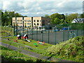
Flats, netball courts and play area
Looking down from Menzies Drive towards a block of flats on Stoneyetts Drive. There is a Spar shop in the corner ground floor, which houses Woodilee Post Office.
Image: © Richard Sutcliffe
Taken: 10 May 2022
0.08 miles
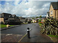
3
View from Menzies Drive
Looking onto the backs of properties on Linnet Drive, which are slightly lower than Menzies Drive.
Image: © Richard Sutcliffe
Taken: 10 May 2022
0.14 miles
4
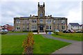
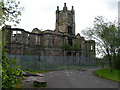
Clocktower building, Woodilee
Originally there was a tower each side flanking the clocktower. A Category B Listed Building. This contributor's mother was a nurse in this hospital during the war (1939-45). For further information see http://homepage.ntlworld.com/sjay.macl/Strathkelvin/woodilee.htm
Image: © Robert Murray
Taken: 3 Oct 2015
0.16 miles
5
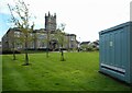
Clock Tower Court
Now private residential accommodation, this was the main block of the former Woodilee Hospital (originally known as the Barony Lunatic Asylum). Built 1871-75, it closed in 2000. It is Category B listed http://portal.historicenvironment.scot/designation/LB13075.
The electricity substation on the right has the notice: 'Clock Tower Court Private Grounds - Keep off grass'.
Image: © Richard Sutcliffe
Taken: 10 May 2022
0.16 miles
6
Clock Tower Court
Now private residential accommodation, this was the main block of the former Woodilee Hospital (originally known as the Barony Lunatic Asylum). Built 1871-75, it closed in 2000. It is Category B listed http://portal.historicenvironment.scot/designation/LB13075.
Image: © Richard Sutcliffe
Taken: 10 May 2022
0.16 miles
7
Woodilee Asylum
Now just a shell, the central building and clock tower along with a few ancillary buildings are all that remain of this previously impressive structure.
Opened in 1875 as the Barony Parochial Asylum at Woodilee it was the largest asylum in Scotland, with 400 inmates. It closed its doors finally in 2001, after cracks appeared in the main block and the patients were evacuated on 'Black Friday (13th March 1987). There are plans to begin developing the site and incorporating parts of the original buildings in 2008-9.
Image: © Raymond Okonski
Taken: 22 May 2007
0.18 miles
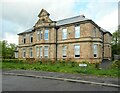
8
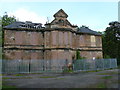
Woodilee Asylum Admin Building
This was the Administration Block at the asylum, and is the only building of any substance on the site (ignoring the gatehouse, which is still operational as an NHS Clinic). Note the monkey puzzle tree on the right, which is nearly 15 metres tall.
Image: © Raymond Okonski
Taken: 22 May 2007
0.18 miles
9
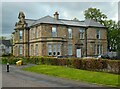
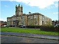
Former Administration Building, Woodilee Hospital
Now private accommodation.
Image: © Richard Sutcliffe
Taken: 10 May 2022
0.19 miles
10
Former Administration Building, Woodilee Hospital
Now private accommodation.
Image: © Richard Sutcliffe
Taken: 10 May 2022
0.20 miles