IMAGES TAKEN NEAR TO
Strathallan Gardens, GLASGOW, G66 3AJ
Introduction
This page details the photographs taken nearby to Strathallan Gardens, G66 3AJ by members of the Geograph project.
The Geograph project started in 2005 with the aim of publishing, organising and preserving representative images for every square kilometre of Great Britain, Ireland and the Isle of Man.

There are currently over 7.5m images from over14,400 individuals and you can help contribute to the project by visiting https://www.geograph.org.uk
Image Map
Images are licensed for reuse under creativecommons.org/licenses/by-sa/2.0
Notes
- Clicking on the map will re-center to the selected point.
- The higher the marker number, the further away the image location is from the centre of the postcode.
Image Listing (151 Images Found)
Images are licensed for reuse under creativecommons.org/licenses/by-sa/2.0
Image
Details
Distance
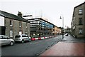
1
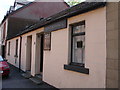
Ebenezer Hall, Kirkintilloch
This rustic building is one of the oldest still standing in the town and has been converted from a typical weaver's workplace (one of the original trades before heavy industry arrived) and the building dates from 1830. It has been a place of worship belonging to a New Testament based Brethren Assembly for many years. Note the unusual placement of the extractor fan, in the middle of the nearest window... was it installed by a height-challenged glazier? The main hall is to the rear, and not visible from the main road. The Library is behind the other two windows. Thanks to SM for the information update.
Image: © Raymond Okonski
Taken: 15 May 2007
0.02 miles
2
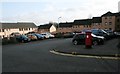
Housing, Belmont Court, Kirkintilloch
Modern brick-built houses, seen from Willowbank Gardens. The pillarbox is postbox number G66 1511.
Image: © Richard Sutcliffe
Taken: 15 Jan 2020
0.05 miles
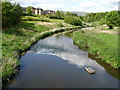
3
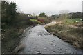
Luggie Water
Looking north from a footbridge over the river Image
Image: © Richard Sutcliffe
Taken: 15 Jan 2020
0.05 miles
4
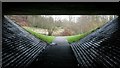
View through the underpass
Looking from one side of the underpass under the A806 to the view on the other side.
Image: © Richard Sutcliffe
Taken: 15 Jan 2020
0.06 miles
5
Building under construction, Townhead, Kirkintilloch
Image: © Richard Sutcliffe
Taken: 10 Jan 2020
0.06 miles
6
Luggie Water, Kirkintilloch
The Council waste bin is a late addition, however this part of Kirkintilloch was previously highly industrialised, and this brownfield site has been given a 'green' makeover. Just past the bend in the Luggie, was the Lion Foundry, famous as one of the UK suppliers to the GPO of the K6 Telephone Box.
The Luggie Water eventually flows under the nearby Forth & Clyde canal before joining with the Glazert Water north of the town to form the River Kelvin, which then flows to join the River Clyde at Glasgow.
Image: © Raymond Okonski
Taken: 15 May 2007
0.06 miles
7
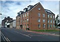
Block of flats
The block of flats on Townhead, at the junction with Willowbank Gardens was constructed in 2020.
Image: © Richard Sutcliffe
Taken: 22 Aug 2023
0.06 miles
8

Roundabout on the A806
Seen from Waterside Road.
Image: © Richard Sutcliffe
Taken: 15 Jan 2020
0.07 miles
9
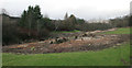
Cleared Rhododendrons
On the east bank of the Luggie Water. The bare ground under where the plants extended shows just how large these Rhododendrons had grown.
Image: © Richard Sutcliffe
Taken: 15 Jan 2020
0.07 miles
10
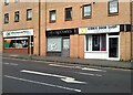
Businesses on Townhead
Minuteman Press (design and printing service), Anthony Charles (hair & beauty) and the Kirkie Door Shop (selling doors).
Image: © Richard Sutcliffe
Taken: 22 Aug 2023
0.07 miles