IMAGES TAKEN NEAR TO
Newdyke Road, GLASGOW, G66 2PY
Introduction
This page details the photographs taken nearby to Newdyke Road, G66 2PY by members of the Geograph project.
The Geograph project started in 2005 with the aim of publishing, organising and preserving representative images for every square kilometre of Great Britain, Ireland and the Isle of Man.

There are currently over 7.5m images from over14,400 individuals and you can help contribute to the project by visiting https://www.geograph.org.uk
Image Map
Images are licensed for reuse under creativecommons.org/licenses/by-sa/2.0
Notes
- Clicking on the map will re-center to the selected point.
- The higher the marker number, the further away the image location is from the centre of the postcode.
Image Listing (6 Images Found)
Images are licensed for reuse under creativecommons.org/licenses/by-sa/2.0
Image
Details
Distance
1
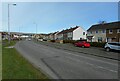
Redbrae Road
Part of the Hillhead area of Kirkintilloch.
Image: © Richard Sutcliffe
Taken: 1 Apr 2022
0.21 miles
2
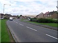
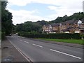
Campsie Fells appear beyond Redbrae Road
In Kirkintilloch.
Image: © Stephen Sweeney
Taken: 4 Sep 2009
0.21 miles
3
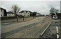
Speed-reducing measures
There are several chicanes along Hillhead Road, with alternate right of ways and give ways. The aim is to reduce the speed of traffic using the road.
Image: © Richard Sutcliffe
Taken: 25 Feb 2022
0.24 miles
4
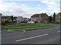
Waverley Crescent, Kirkintilloch
Residential street to the east of the town centre.
Image: © Stephen Sweeney
Taken: 4 Sep 2009
0.24 miles
5
Redbrae Road, Kirkintilloch
Leads to the town centre from the east.
Image: © Stephen Sweeney
Taken: 4 Sep 2009
0.24 miles
6
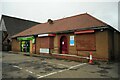
Shop and dental surgery
Londis is urging people to 'shop local'. The dental surgery is 'Kirkintilloch Smiles'.
Image: © Richard Sutcliffe
Taken: 25 Feb 2022
0.25 miles