IMAGES TAKEN NEAR TO
Dun Park, GLASGOW, G66 2DU
Introduction
This page details the photographs taken nearby to Dun Park, G66 2DU by members of the Geograph project.
The Geograph project started in 2005 with the aim of publishing, organising and preserving representative images for every square kilometre of Great Britain, Ireland and the Isle of Man.

There are currently over 7.5m images from over14,400 individuals and you can help contribute to the project by visiting https://www.geograph.org.uk
Image Map
Images are licensed for reuse under creativecommons.org/licenses/by-sa/2.0
Notes
- Clicking on the map will re-center to the selected point.
- The higher the marker number, the further away the image location is from the centre of the postcode.
Image Listing (52 Images Found)
Images are licensed for reuse under creativecommons.org/licenses/by-sa/2.0
Image
Details
Distance
3
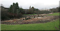
Cleared Rhododendrons
On the east bank of the Luggie Water. The bare ground under where the plants extended shows just how large these Rhododendrons had grown.
Image: © Richard Sutcliffe
Taken: 15 Jan 2020
0.10 miles
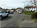
4
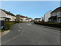
Waverley Crescent
A quiet residential street in Hillhead.
Image: © Richard Sutcliffe
Taken: 1 Apr 2022
0.10 miles
5
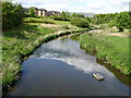
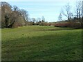
Luggie Water, Kirkintilloch
The Council waste bin is a late addition, however this part of Kirkintilloch was previously highly industrialised, and this brownfield site has been given a 'green' makeover. Just past the bend in the Luggie, was the Lion Foundry, famous as one of the UK suppliers to the GPO of the K6 Telephone Box.
The Luggie Water eventually flows under the nearby Forth & Clyde canal before joining with the Glazert Water north of the town to form the River Kelvin, which then flows to join the River Clyde at Glasgow.
Image: © Raymond Okonski
Taken: 15 May 2007
0.11 miles
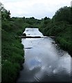
6
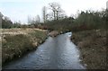
Luggie Water
Looking southeast from the footbridge Image The river divides here, forming a small island.
Image: © Richard Sutcliffe
Taken: 15 Jan 2020
0.11 miles
7
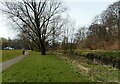
Footpath beside the Luggie Water
In Luggie Park.
Image: © Richard Sutcliffe
Taken: 1 Apr 2022
0.11 miles
9
Waverley Crescent
A quiet residential street in Hillhead.
Image: © Richard Sutcliffe
Taken: 1 Apr 2022
0.12 miles
10
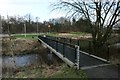
Luggie Water, Kirkintilloch
Flowing over a succession of shallow weirs through attractive parkland east of the town centre.
Image: © Robert Murray
Taken: 29 May 2010
0.12 miles