IMAGES TAKEN NEAR TO
Auchendavie Road, GLASGOW, G66 2AG
Introduction
This page details the photographs taken nearby to Auchendavie Road, G66 2AG by members of the Geograph project.
The Geograph project started in 2005 with the aim of publishing, organising and preserving representative images for every square kilometre of Great Britain, Ireland and the Isle of Man.

There are currently over 7.5m images from over14,400 individuals and you can help contribute to the project by visiting https://www.geograph.org.uk
Image Map
Images are licensed for reuse under creativecommons.org/licenses/by-sa/2.0
Notes
- Clicking on the map will re-center to the selected point.
- The higher the marker number, the further away the image location is from the centre of the postcode.
Image Listing (6 Images Found)
Images are licensed for reuse under creativecommons.org/licenses/by-sa/2.0
Image
Details
Distance
1
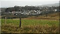
Houses on the outskirts of Kirkintilloch
The nearest houses are on Lorn Place.
Image: © Richard Sutcliffe
Taken: 25 Feb 2022
0.12 miles
2
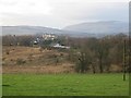
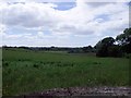
Scrub, Langmuir Road
A long uncultivated field on the edge of Kirkintilloch. View up Strathblane.
Image: © Richard Webb
Taken: 19 Jan 2014
0.12 miles
3
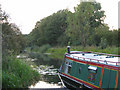
Forth & Clyde Canal at Tintock, near Kirkintilloch
A canal boat moored on a quiet stretch of the recently re-opened Forth & Clyde Canal - now again navigable from sea to sea
Image: © Brian D Osborne
Taken: 6 Sep 2005
0.20 miles
4
Tintock from across the Forth and Clyde Canal
Just east of Kirkintilloch.
Image: © Stephen Sweeney
Taken: 10 Nov 2010
0.22 miles
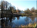
5

Forth and Clyde Canal
Just outside Kirkintilloch.
Image: © G Laird
Taken: 24 Jun 2012
0.24 miles
6
Fields south of Tintock
And west of Langmuir Road.
Image: © Robert Murray
Taken: 12 Jun 2010
0.24 miles