IMAGES TAKEN NEAR TO
Kirkintilloch, GLASGOW, G66 1RS
Introduction
This page details the photographs taken nearby to G66 1RS by members of the Geograph project.
The Geograph project started in 2005 with the aim of publishing, organising and preserving representative images for every square kilometre of Great Britain, Ireland and the Isle of Man.

There are currently over 7.5m images from over14,400 individuals and you can help contribute to the project by visiting https://www.geograph.org.uk
Image Map
Images are licensed for reuse under creativecommons.org/licenses/by-sa/2.0
Notes
- Clicking on the map will re-center to the selected point.
- The higher the marker number, the further away the image location is from the centre of the postcode.
Image Listing (9 Images Found)
Images are licensed for reuse under creativecommons.org/licenses/by-sa/2.0
Image
Details
Distance
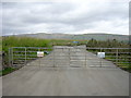
3
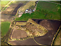
Inchbelle Farm from the air
Surrounded by a former gravel quarry and landfill site.
The route of the former North British Railway Kelvin Valley Line at Glazert Bridge Image can be seen running up from the lower left corner. A spur to the NBR line to Kirkintilloch can also be seen there.
Image: © Thomas Nugent
Taken: 7 Apr 2016
0.12 miles
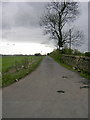
4
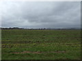
Farmland near Inchbelle Farm
West from the A803.
Image: © JThomas
Taken: 30 Mar 2017
0.15 miles
8
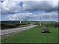
Kirkintilloch to Kilsyth road, A803
At Inchterf.
Image: © Robert Murray
Taken: 25 Aug 2010
0.22 miles
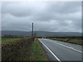
9
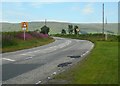
Bend on the A803
Just after leaving Kirkintilloch, heading for Kilsyth.
Image: © Richard Sutcliffe
Taken: 31 Jul 2020
0.24 miles