IMAGES TAKEN NEAR TO
Canal Street, GLASGOW, G66 1QZ
Introduction
This page details the photographs taken nearby to Canal Street, G66 1QZ by members of the Geograph project.
The Geograph project started in 2005 with the aim of publishing, organising and preserving representative images for every square kilometre of Great Britain, Ireland and the Isle of Man.

There are currently over 7.5m images from over14,400 individuals and you can help contribute to the project by visiting https://www.geograph.org.uk
Image Map
Images are licensed for reuse under creativecommons.org/licenses/by-sa/2.0
Notes
- Clicking on the map will re-center to the selected point.
- The higher the marker number, the further away the image location is from the centre of the postcode.
Image Listing (222 Images Found)
Images are licensed for reuse under creativecommons.org/licenses/by-sa/2.0
Image
Details
Distance
1
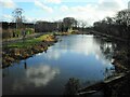
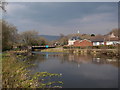
The Hillhead Basin
Looking south from the swing bridge at Hillhead Road, over the basin on the Forth and Clyde Canal.
Image: © Richard Sutcliffe
Taken: 17 Feb 2022
0.01 miles
2
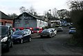
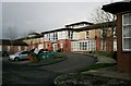
Soaperie, Canal Street, Kirkintilloch
Dating from 1922, this is the oldest and last working soaperie operating the coldprocess method in the world. See https://caurnie.com/.
Image: © Richard Sutcliffe
Taken: 15 Jan 2020
0.01 miles
3
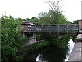
Footbridge over the Luggie, Kirkintilloch
Situated in a built up area east of the town centre.
Image: © Robert Murray
Taken: 29 May 2010
0.04 miles
5
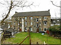
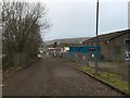
Rear of tenement block
Looking from Hillhead Road onto the rear of a tenement block on Eastside. The flats on the left have done away with the communal toilets, which would have been accessed off the landings of the close, and the external structure has been removed. The flats on the right still retain the spaces, but it is quite likely they are no longer in use as toilets.
Image: © Richard Sutcliffe
Taken: 27 Feb 2023
0.05 miles
7
Hillhead Basin of the Forth and Clyde Canal
The canal basin sits next to the Hillhead Bridge (e.g. Image), seen centre left in this picture with a big blue sign saying "Hillhead Basin". From the Canmore database of historic sites we learn that this was originally Kirkintilloch Harbour, dating from the 18th century: https://canmore.org.uk/site/168463/forth-and-clyde-canal-kirkintilloch-harbour
Image: © Alec MacKinnon
Taken: 12 Apr 2019
0.06 miles
8
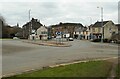
Hillhead Roundabout
Looking beyond the roundabout, down Eastside.
Image: © Richard Sutcliffe
Taken: 27 Feb 2023
0.06 miles
9
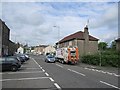
Bin day, Eastside
Collecting refuse in Kirkintilloch.
Image: © Richard Webb
Taken: 1 Jun 2012
0.06 miles
10
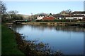
The Hillhead Basin
A wide part of the Forth and Clyde Canal, approaching the swing bridge at Hillhead Road.
Image: © Richard Sutcliffe
Taken: 23 Feb 2020
0.06 miles