IMAGES TAKEN NEAR TO
Ailsa Drive, GLASGOW, G66 1QX
Introduction
This page details the photographs taken nearby to Ailsa Drive, G66 1QX by members of the Geograph project.
The Geograph project started in 2005 with the aim of publishing, organising and preserving representative images for every square kilometre of Great Britain, Ireland and the Isle of Man.

There are currently over 7.5m images from over14,400 individuals and you can help contribute to the project by visiting https://www.geograph.org.uk
Image Map (Loading...)


Getting Data...Please wait
Leaflet Map data © OpenStreetMap
Images are licensed for reuse under creativecommons.org/licenses/by-sa/2.0
Notes
- Clicking on the map will re-center to the selected point.
- The higher the marker number, the further away the image location is from the centre of the postcode.
Image Listing (28 Images Found)
Images are licensed for reuse under creativecommons.org/licenses/by-sa/2.0
Image
Details
Distance
2
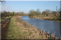
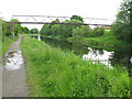
Forth and Clyde Canal
Canal and towpath, looking northeast.
Image: © Richard Sutcliffe
Taken: 23 Feb 2020
0.04 miles
3
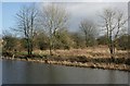
The Antonine Wall adjacent to the Forth and Clyde Canal
The area to the east of the canal at this point is the site of the now flattened rampart, ditch, berm (the area between rampart and ditch) and the mound of the Antonine Wall itself. Once the northern-most boundary of the Roman Empire, it is today a Scheduled Monument http://portal.historicenvironment.scot/designation/SM90324.
Image: © Richard Sutcliffe
Taken: 23 Feb 2020
0.08 miles
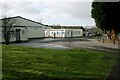
4
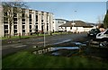
Council offices
Some of East Dunbartonshire Council's offices, Kirkintilloch.
Image: © Richard Sutcliffe
Taken: 23 Feb 2020
0.09 miles
5
Pipe Bridge across the Forth and Clyde Canal
In the eastern outskirts of Kirkintilloch.
Image: © G Laird
Taken: 24 Jun 2012
0.09 miles
6
Ritchie MacKenzie & Co Ltd (Ritmac Pumps)
Business in Broomhill Industrial Estate, Kirkintilloch.
Image: © Richard Sutcliffe
Taken: 23 Feb 2020
0.10 miles
7
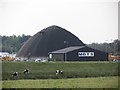
Salt dome
A big shed protects road salt from the rain.
Image: © Richard Webb
Taken: 30 Sep 2011
0.10 miles
8
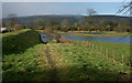
Riverside path
Looking from the A803, Kilsyth Road towards the River Kelvin (behind the trees). Unfortunately, the river has broken its banks following very heavy rainfall, and the path is currently IN the river!
Image: © Richard Sutcliffe
Taken: 23 Feb 2020
0.10 miles
9
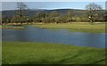
Flooded field
Following very heavy rain the previous day, the River Kelvin (just behind the treeline) broke its banks and flooded many fields in the area.
Image: © Richard Sutcliffe
Taken: 23 Feb 2020
0.10 miles
10
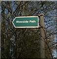
Sign for Riverside Path
The path leads from the A803, Kilsyth Road to the River Kelvin Image
Image: © Richard Sutcliffe
Taken: 23 Feb 2020
0.11 miles