IMAGES TAKEN NEAR TO
Salford Place, GLASGOW, G66 1PL
Introduction
This page details the photographs taken nearby to Salford Place, G66 1PL by members of the Geograph project.
The Geograph project started in 2005 with the aim of publishing, organising and preserving representative images for every square kilometre of Great Britain, Ireland and the Isle of Man.

There are currently over 7.5m images from over14,400 individuals and you can help contribute to the project by visiting https://www.geograph.org.uk
Image Map
Images are licensed for reuse under creativecommons.org/licenses/by-sa/2.0
Notes
- Clicking on the map will re-center to the selected point.
- The higher the marker number, the further away the image location is from the centre of the postcode.
Image Listing (267 Images Found)
Images are licensed for reuse under creativecommons.org/licenses/by-sa/2.0
Image
Details
Distance
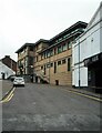
1
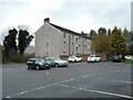
Salford Place, Kirkintilloch
A block of flats beside the car park for William Patrick Library.
Image: © Richard Sutcliffe
Taken: 16 Nov 2022
0.02 miles
2
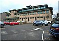
William Patrick Library
Seen from the car park at the rear of the building. A car park attendant is checking parking tickets.
Image: © Richard Sutcliffe
Taken: 16 Nov 2022
0.04 miles
3

The A8006, Kirkintilloch
Main road in the town centre. In the process of being extended to the south.
Image: © Stephen Sweeney
Taken: 4 Sep 2009
0.05 miles
4
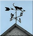
Cat and mice
A delightful weather vane on top of the 'Wee House' - an early 19th century Category C listed house http://portal.historicenvironment.scot/designation/LB36652.
Image: © Richard Sutcliffe
Taken: 16 Nov 2022
0.05 miles
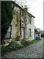
5
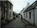
8 West High Street, Kirkintilloch
There is a group of properties accessed through a vennel on West High Street Image The building on the left is a Category B listed http://portal.historicenvironment.scot/designation/LB36653 late 18th century house, which is in poor condition and is in the Buildings at Risk Register https://www.buildingsatrisk.org.uk/details/906932. On the right is a Category C listed http://portal.historicenvironment.scot/designation/LB36650 early 19th century single storey cottage, behind which is a Category B listed http://portal.historicenvironment.scot/designation/LB36651 early 18th century two storey property with a forestair.
Image: © Richard Sutcliffe
Taken: 16 Nov 2022
0.05 miles
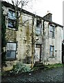
6
Derelict house
A late 18th century house at 8 West High Street, Kirkintilloch, which is in poor condition. The property has been vacant since before 2007. It is Category B listed http://portal.historicenvironment.scot/designation/LB36653 and is in the Buildings at Risk Register https://www.buildingsatrisk.org.uk/details/906932.
Image: © Richard Sutcliffe
Taken: 16 Nov 2022
0.06 miles
7
Derelict house
A late 18th century house at 8 West High Street, Kirkintilloch, which is in very poor condition. There is a tree growing out of the upper floor window. The property has been vacant since before 2007. It is Category B listed http://portal.historicenvironment.scot/designation/LB36653 and is in the Buildings at Risk Register https://www.buildingsatrisk.org.uk/details/906932.
Image: © Richard Sutcliffe
Taken: 7 Jan 2023
0.06 miles
8
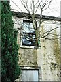
Tree house
The tree is growing out through an upper window of a late 18th century house at 8 West High Street, Kirkintilloch, which is in very poor condition. The property has been vacant since before 2007. It is Category B listed http://portal.historicenvironment.scot/designation/LB36653 and is in the Buildings at Risk Register https://www.buildingsatrisk.org.uk/details/906932.
Image: © Richard Sutcliffe
Taken: 7 Jan 2023
0.06 miles
9
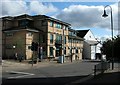
William Patrick Library, Kirkintilloch
The library is also a community hub.
Image: © Richard Sutcliffe
Taken: 30 Jul 2015
0.06 miles
10
William Patrick Library
Kirkintilloch's library, which is also a community hub.
Image: © Richard Sutcliffe
Taken: 16 Nov 2022
0.06 miles