IMAGES TAKEN NEAR TO
Broomhill Drive, G66 1FB
Introduction
This page details the photographs taken nearby to Broomhill Drive, G66 1FB by members of the Geograph project.
The Geograph project started in 2005 with the aim of publishing, organising and preserving representative images for every square kilometre of Great Britain, Ireland and the Isle of Man.

There are currently over 7.5m images from over14,400 individuals and you can help contribute to the project by visiting https://www.geograph.org.uk
Image Map
Images are licensed for reuse under creativecommons.org/licenses/by-sa/2.0
Notes
- Clicking on the map will re-center to the selected point.
- The higher the marker number, the further away the image location is from the centre of the postcode.
Image Listing (25 Images Found)
Images are licensed for reuse under creativecommons.org/licenses/by-sa/2.0
Image
Details
Distance
1
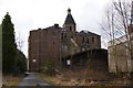
Broomhill Hospital (derelict)
Image: © Texas Radio and The Big Beat
Taken: 4 Apr 2010
0.04 miles
2
Broomhill Hospital (derelict)
Closed in 1995.
Image: © Texas Radio and The Big Beat
Taken: 4 Apr 2010
0.05 miles
3
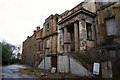
Broomhill Hospital (derelict)
Closed in 1995 and now lying derelict.
Image: © Texas Radio and The Big Beat
Taken: 4 Apr 2010
0.05 miles
4
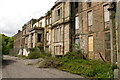
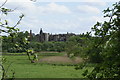
Broomhill & Lanfine Hospitals, Kirkintilloch
A beautiful building - but the future it faces seems to be demolition, having been a target for vandals over the years. The original building on the site was purchased in 1876 and opened for business. It catered for patients suffering from tuberculosis, cancer, chronic rheumatism and other incurable conditions. Paupers were not to be admitted. Additions to the main building increased the number of patients that could be treated. In 1904 the adjacent Lanfine house was incorporated into the hospital complex and Lanfine Home was opened.
Both hospitals closed in 1995, after 119 years serving the public.
Image: © Raymond Okonski
Taken: 20 May 2007
0.06 miles
5
Broomhill Hospital (Disused)
Taken from the railway embankment of the Kelvin Valley Railway, this hospital closed in the esrly 1990's due to flooding and had recently suffered damage due to fire. It is now largely forgotten by the people of Kirkintilloch.
Image: © Raymond Okonski
Taken: 18 May 2007
0.06 miles
6
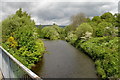
Confluence of the Glazert & Kelvin
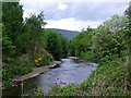
Looking east from the footbridge that replaced the original Campsie Branch railway, the water below is the River Kelvin, which makes its way to the River Clyde in the centre of Glasgow. In the distance you can see where the Glazert Water (left) joins the River Kelvin (right). With the Luggie water similarly joining the Kelvin a few hundred metres downstream this confluence was instrumental in causing flooding in to new homes that developers erected on the Kelvin flood plain. The local council then had to spend millions in building a flood prevention scheme to protect them.
Image: © Raymond Okonski
Taken: 20 May 2007
0.15 miles
7
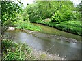
Glazert and Kelvin
The muddy waters of the Kelvin discharge into the sparkling Glazert.
Image: © Robert Murray
Taken: 29 May 2010
0.15 miles
9
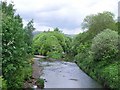
Confluence of Glazert and Kelvin waters
Just north of the Kirkintilloch town centre. The Kelvin name carries the day after these two waters meet but a blind dog would notice that the Glazert is the major waterway and the Kelvin a tributary of it.
Image: © Robert Murray
Taken: 29 May 2010
0.16 miles
10
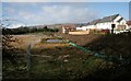
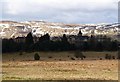
New houses, Broomhill
New houses, some recently completed, others still under construction. Part of a new development by Cala Homes at Broomhill, Kirkintilloch. The houses are built up above bunds to prevent flooding from the nearby River Kelvin. The ground on the left has been left as an area where the river can flood - which it has just done.
Image: © Richard Sutcliffe
Taken: 23 Feb 2020
0.18 miles