IMAGES TAKEN NEAR TO
Union Street, GLASGOW, G66 1DG
Introduction
This page details the photographs taken nearby to Union Street, G66 1DG by members of the Geograph project.
The Geograph project started in 2005 with the aim of publishing, organising and preserving representative images for every square kilometre of Great Britain, Ireland and the Isle of Man.

There are currently over 7.5m images from over14,400 individuals and you can help contribute to the project by visiting https://www.geograph.org.uk
Image Map
Images are licensed for reuse under creativecommons.org/licenses/by-sa/2.0
Notes
- Clicking on the map will re-center to the selected point.
- The higher the marker number, the further away the image location is from the centre of the postcode.
Image Listing (318 Images Found)
Images are licensed for reuse under creativecommons.org/licenses/by-sa/2.0
Image
Details
Distance
1
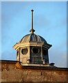
Town hall cupola
On the 1905 Category B listed http://portal.historicenvironment.scot/designation/LB48641, building on Union Street Image
Image: © Richard Sutcliffe
Taken: 7 Jan 2023
0.02 miles
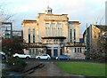
2
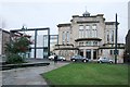
Kirkintilloch Town Hall, Union Street
A Category B listed building http://portal.historicenvironment.scot/designation/LB48641, dating from 1905, with a modern extension attached.
Image: © Richard Sutcliffe
Taken: 10 Jan 2020
0.02 miles
3
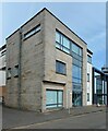
Regent Gardens Medical Centre
The medical practice has existed since about 1910, and has been based in several locations within Kirkintilloch. It moved to this site on Union Street in 1962. The current building dates from 2008.
Image: © Richard Sutcliffe
Taken: 1 Apr 2022
0.02 miles
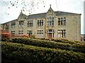
4
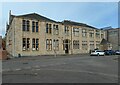
St Ninian's Church Hall
What at first glance looks like it was built as one building was actually built in two stages. The part to the right (including the now central doorway) was built first as a Roman Catholic school by the adjacent Church of Holy Family and St Ninian; and was enlarged in 1895. The part on the left was added later. It became the church hall in the 1930s after a new school was opened elsewhere in Kirkintilloch..
It is Category B listed http://portal.historicenvironment.scot/designation/LB48642.
Image: © Richard Sutcliffe
Taken: 1 Apr 2022
0.03 miles
5
Kirkintilloch Town Hall
A Category B listed building http://portal.historicenvironment.scot/designation/LB48641, dating from 1905, with a modern extension attached (left). Bathed in late afternoon sunshine.
Image: © Richard Sutcliffe
Taken: 7 Jan 2023
0.03 miles
6
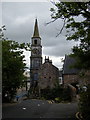
Kirkintilloch Cross Clock
Kirkie Cross clock from Peel Park
Image: © Bill Jarvie
Taken: Unknown
0.03 miles
7
St Ninian's Church Hall
Built as part of a Roman Catholic school by the adjacent Church of Holy Family and St Ninian. It became the church hall in the 1930s after a new school was opened elsewhere in Kirkintilloch. See Image for another view and more information.
Image: © Richard Sutcliffe
Taken: 25 Apr 2022
0.03 miles
8
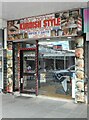
Star Barber
Kurdish style barber on Cowgate, Kirkintilloch.
Image: © Richard Sutcliffe
Taken: 22 Aug 2023
0.03 miles
9
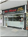
Mr. Rice
Chinese takeaway and home delivery on Cowgate, Kirkintilloch.
Image: © Richard Sutcliffe
Taken: 22 Aug 2023
0.03 miles
10
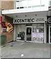
Xcentric
Hair & beauty bar on Cowgate, Kirkintilloch.
Image: © Richard Sutcliffe
Taken: 22 Aug 2023
0.03 miles