IMAGES TAKEN NEAR TO
Kelvin Way, GLASGOW, G66 1BU
Introduction
This page details the photographs taken nearby to Kelvin Way, G66 1BU by members of the Geograph project.
The Geograph project started in 2005 with the aim of publishing, organising and preserving representative images for every square kilometre of Great Britain, Ireland and the Isle of Man.

There are currently over 7.5m images from over14,400 individuals and you can help contribute to the project by visiting https://www.geograph.org.uk
Image Map
Images are licensed for reuse under creativecommons.org/licenses/by-sa/2.0
Notes
- Clicking on the map will re-center to the selected point.
- The higher the marker number, the further away the image location is from the centre of the postcode.
Image Listing (7 Images Found)
Images are licensed for reuse under creativecommons.org/licenses/by-sa/2.0
Image
Details
Distance
1
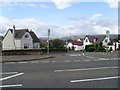
Adamslie Crescent, Hayston
And the Campsie Fells.
Image: © Stephen Sweeney
Taken: 4 Sep 2009
0.06 miles

4
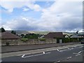
Campsie Fells from Glasgow Road
Across the rooftops of Hayston.
Image: © Stephen Sweeney
Taken: 4 Sep 2009
0.18 miles
5
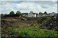
Construction site
Site for new 4 and 5 bedroom homes, to be called Adamslie Park.
Image: © Richard Sutcliffe
Taken: 10 May 2022
0.18 miles
6
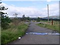
Road to sewage works near Kirkintilloch
To the west of the town, near Glasgow Bridge.
Image: © Stephen Sweeney
Taken: 4 Sep 2009
0.19 miles
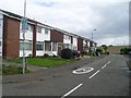
7
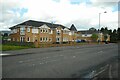
Hayston Court
Properties just off Glasgow Road.
Image: © Richard Sutcliffe
Taken: 10 May 2022
0.24 miles