IMAGES TAKEN NEAR TO
Twechar, Kilsyth, GLASGOW, G65 9TW
Introduction
This page details the photographs taken nearby to G65 9TW by members of the Geograph project.
The Geograph project started in 2005 with the aim of publishing, organising and preserving representative images for every square kilometre of Great Britain, Ireland and the Isle of Man.

There are currently over 7.5m images from over14,400 individuals and you can help contribute to the project by visiting https://www.geograph.org.uk
Image Map
Images are licensed for reuse under creativecommons.org/licenses/by-sa/2.0
Notes
- Clicking on the map will re-center to the selected point.
- The higher the marker number, the further away the image location is from the centre of the postcode.
Image Listing (8 Images Found)
Images are licensed for reuse under creativecommons.org/licenses/by-sa/2.0
Image
Details
Distance
1
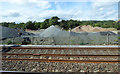
Cemex concrete plant
By the railway, just west of Croy station.
See also Image
Image: © Thomas Nugent
Taken: 29 Aug 2016
0.03 miles
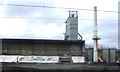
3
Cemex concrete plant
By the railway, just west of Croy station.
See also Image
Image: © Thomas Nugent
Taken: 29 Aug 2016
0.04 miles

5
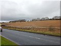
Drumgrew Plantation
On a hillside by the B8048.
Image: © Stephen Sweeney
Taken: 20 Dec 2011
0.21 miles
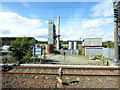
6

A Train Passing Drumgrew
Image: © Texas Radio and The Big Beat
Taken: 19 Aug 2010
0.21 miles
7

Field of Oats, Drumgrew
Probably the only crop that would thrive in this damp, north facing field.
Image: © Texas Radio and The Big Beat
Taken: 19 Aug 2010
0.23 miles
8

I've Got A Brand New Combine Harvester!
Not quite! This John Deere 955 was abandoned a few years ago.
It has become a bit of a landmark as it sits on top of a hill
and is visible from the main road.
Also see Richard Webb's picture www.geograph.org.uk/photo/2299697
Image: © Texas Radio and The Big Beat
Taken: 19 Aug 2010
0.24 miles