IMAGES TAKEN NEAR TO
Drumglass, GLASGOW, G65 9TR
Introduction
This page details the photographs taken nearby to Drumglass, G65 9TR by members of the Geograph project.
The Geograph project started in 2005 with the aim of publishing, organising and preserving representative images for every square kilometre of Great Britain, Ireland and the Isle of Man.

There are currently over 7.5m images from over14,400 individuals and you can help contribute to the project by visiting https://www.geograph.org.uk
Image Map
Images are licensed for reuse under creativecommons.org/licenses/by-sa/2.0
Notes
- Clicking on the map will re-center to the selected point.
- The higher the marker number, the further away the image location is from the centre of the postcode.
Image Listing (6 Images Found)
Images are licensed for reuse under creativecommons.org/licenses/by-sa/2.0
Image
Details
Distance
1
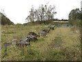
A landfill site
Now full and overgrown, this was the entrance to a landfill site.
Image: © Richard Webb
Taken: 14 Oct 2011
0.10 miles
2
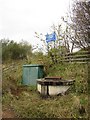
Hope Park landfill site
An inspection hatch and seepage of iron rich water at a closed landfill site.
Image: © Richard Webb
Taken: 14 Oct 2011
0.11 miles
4
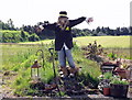
The Drumglass Scarecrow
Well dressed character with his little football pitch in the background - most of which is in the next square.
Image: © Robert Murray
Taken: 24 Apr 2010
0.20 miles
5
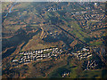
Croy from the air
Croy Quarry dominates the scene.
Image: © Thomas Nugent
Taken: 8 Dec 2017
0.20 miles
6
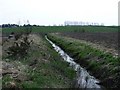
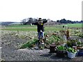
Drumglass drain
A recently dug drain which empties into the Broad Burn. Serious attempts are being made to drain the bog by deepening the burn's channel but so far to no avail.
Image: © Robert Murray
Taken: 24 Apr 2010
0.20 miles