IMAGES TAKEN NEAR TO
Gartshore Crescent, GLASGOW, G65 9SY
Introduction
This page details the photographs taken nearby to Gartshore Crescent, G65 9SY by members of the Geograph project.
The Geograph project started in 2005 with the aim of publishing, organising and preserving representative images for every square kilometre of Great Britain, Ireland and the Isle of Man.

There are currently over 7.5m images from over14,400 individuals and you can help contribute to the project by visiting https://www.geograph.org.uk
Image Map
Images are licensed for reuse under creativecommons.org/licenses/by-sa/2.0
Notes
- Clicking on the map will re-center to the selected point.
- The higher the marker number, the further away the image location is from the centre of the postcode.
Image Listing (18 Images Found)
Images are licensed for reuse under creativecommons.org/licenses/by-sa/2.0
Image
Details
Distance
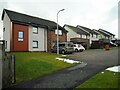
1
Differ Avenue
Seen from Gartshore Crescent. The Campsie Fells are in the distance.
Image: © Richard Sutcliffe
Taken: 25 Feb 2022
0.05 miles
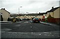
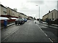
2
Gartshore Crescent
Seen from the junction with Differ Avenue.
Image: © Richard Sutcliffe
Taken: 25 Feb 2022
0.05 miles
3
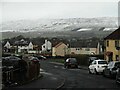
Looking down Differ Avenue
The Campsie Fells are in the distance.
Image: © Richard Sutcliffe
Taken: 25 Feb 2022
0.08 miles
4
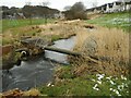
Pipe bridge
Over the Board Burn. The houses in the distance are on MacDonald Crescent.
Image: © Richard Sutcliffe
Taken: 25 Feb 2022
0.10 miles
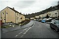
5
Gartshore Crescent
Seen from the junction with Differ Avenue.
Image: © Richard Sutcliffe
Taken: 25 Feb 2022
0.11 miles
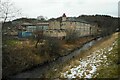
6
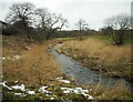
The Board Burn
With a bit of snow.
Image: © Richard Sutcliffe
Taken: 25 Feb 2022
0.11 miles
7
Gartshore Crescent
Houses on the edge of Twechar.
Image: © Richard Sutcliffe
Taken: 25 Feb 2022
0.17 miles
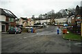
8
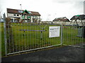
Baird Drive Play Area
A small play area beside houses on Baird Drive, Twechar.
Image: © Richard Sutcliffe
Taken: 25 Feb 2022
0.17 miles
9
Twechar Primary School
Beside the Board Burn.
Image: © Richard Sutcliffe
Taken: 25 Feb 2022
0.18 miles