IMAGES TAKEN NEAR TO
Alexander Avenue, GLASGOW, G65 9RJ
Introduction
This page details the photographs taken nearby to Alexander Avenue, G65 9RJ by members of the Geograph project.
The Geograph project started in 2005 with the aim of publishing, organising and preserving representative images for every square kilometre of Great Britain, Ireland and the Isle of Man.

There are currently over 7.5m images from over14,400 individuals and you can help contribute to the project by visiting https://www.geograph.org.uk
Image Map
Images are licensed for reuse under creativecommons.org/licenses/by-sa/2.0
Notes
- Clicking on the map will re-center to the selected point.
- The higher the marker number, the further away the image location is from the centre of the postcode.
Image Listing (15 Images Found)
Images are licensed for reuse under creativecommons.org/licenses/by-sa/2.0
Image
Details
Distance
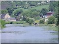
1
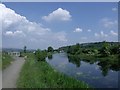
Forth & Clyde Canal
West of Twechar bridge.
Image: © Robert Murray
Taken: 5 Jun 2010
0.09 miles
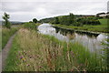
2
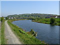
Canal at Twechar
The Roman Antonine Wall ran along the right bank of the canal but as only a ditch remains, it is impossible to see. The line of the wall followed a straight line to the Roman Fort on Barr Hill (in the distance).
Image: © Raymond Okonski
Taken: 3 May 2007
0.12 miles
3
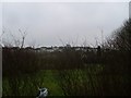
Houses in Twechar
From Twechar Enterprise Park.
Image: © Stephen Sweeney
Taken: 26 Jan 2010
0.14 miles
4
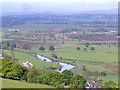
Forth & Clyde canal
View from Bar Hill up Twechar
Image: © Michel Van den Berghe
Taken: 24 May 2005
0.14 miles
5
Thirsty cows
Having a drink on a hot afternoon. Twechar Farm and part of the old village can be seen in the background.
Image: © Robert Murray
Taken: 5 Jun 2010
0.15 miles
6

Forth and Clyde Canal, Towpath and Road (B8023)
Approaching Twechar.
Image: © G Laird
Taken: 24 Jun 2012
0.16 miles
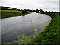
7
Forth and Clyde Canal
Looking towards Twechar.
Image: © Richard Sutcliffe
Taken: 3 Aug 2010
0.16 miles
8
Forth and Clyde Canal at Twechar
Canal scene at Twechar as I follow the towpath towards Kirkintilloch.
Image: © Chris Heaton
Taken: 11 Aug 2009
0.16 miles
9
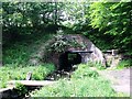
Board Burn flowing through aqueduct.
This tunnel allows this burn (also called the Broad Burn by the O.S. but which is called Moss Water at its source) to flow under the Forth & Clyde canal towards the Kelvin. Alongside is a raised pedestrian subway which allows access to the north side of the canal and the towpath. This aqueduct is also known locally as Shirva Pend.
Image: © Robert Murray
Taken: 5 Jun 2010
0.17 miles
10
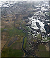
The Forth and Clyde Canal from the air
At Twechar, which is in the foreground.
Image: © Thomas Nugent
Taken: 24 Feb 2017
0.18 miles