IMAGES TAKEN NEAR TO
Rennie Road, GLASGOW, G65 9PR
Introduction
This page details the photographs taken nearby to Rennie Road, G65 9PR by members of the Geograph project.
The Geograph project started in 2005 with the aim of publishing, organising and preserving representative images for every square kilometre of Great Britain, Ireland and the Isle of Man.

There are currently over 7.5m images from over14,400 individuals and you can help contribute to the project by visiting https://www.geograph.org.uk
Image Map
Images are licensed for reuse under creativecommons.org/licenses/by-sa/2.0
Notes
- Clicking on the map will re-center to the selected point.
- The higher the marker number, the further away the image location is from the centre of the postcode.
Image Listing (5 Images Found)
Images are licensed for reuse under creativecommons.org/licenses/by-sa/2.0
Image
Details
Distance
1
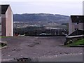
Empty car park, Kilsyth
Northfield area with Dumbreck Marsh and Castle Hill in the distance.
Image: © Robert Murray
Taken: 24 Apr 2010
0.12 miles
2
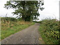
Track and footpath to Allanfauld
Looking eastward from Balcastle Farm.
Image: © Peter Wood
Taken: 3 Sep 2022
0.17 miles
3
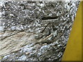
Ordnance Survey Cut Mark
This mark can be found on the wall of a barn at Balcastle Farm.
The recorded details give a height of 121.9627 metres above sea level.
For more detail see : https://www.bench-marks.org.uk/bm179742
Image: © Peter Wood
Taken: 3 Sep 2022
0.20 miles
5
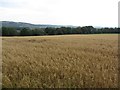
Oats, Balcastle Road
A field of oats on the west side of Balcastle Road.
Image: © Richard Webb
Taken: 30 Sep 2011
0.23 miles