IMAGES TAKEN NEAR TO
Gavell Road, GLASGOW, G65 9LP
Introduction
This page details the photographs taken nearby to Gavell Road, G65 9LP by members of the Geograph project.
The Geograph project started in 2005 with the aim of publishing, organising and preserving representative images for every square kilometre of Great Britain, Ireland and the Isle of Man.

There are currently over 7.5m images from over14,400 individuals and you can help contribute to the project by visiting https://www.geograph.org.uk
Image Map
Images are licensed for reuse under creativecommons.org/licenses/by-sa/2.0
Notes
- Clicking on the map will re-center to the selected point.
- The higher the marker number, the further away the image location is from the centre of the postcode.
Image Listing (48 Images Found)
Images are licensed for reuse under creativecommons.org/licenses/by-sa/2.0
Image
Details
Distance
1
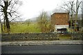
Works beside the B8023
Looking north-west over farmland.
Image: © Richard Sutcliffe
Taken: 9 Mar 2020
0.01 miles
2
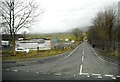
Works beside the B8023
The road straight ahead leads to Queenzieburn.
Image: © Richard Sutcliffe
Taken: 9 Mar 2020
0.02 miles
3
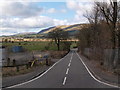
Minor road from Queenzieburn to Twechar
The minor road that runs south from Queenzieburn is seen at its Twechar end, where it meets the B8023. The picture looks north along the minor road, from the canal tow path.
Image: © Alec MacKinnon
Taken: 28 Mar 2016
0.02 miles
4
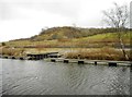
Wharf and slipway, Twechar
Looking across the Forth and Clyde Canal, with an old mine spoilheap in the distance.
Image: © Richard Sutcliffe
Taken: 9 Mar 2020
0.06 miles
6
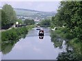
Boats approaching Twechar bridge
Part of Kilsyth town can be seen in the background.
Image: © Robert Murray
Taken: 5 Jun 2010
0.06 miles
7

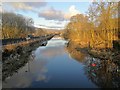
The Forth and Clyde Canal from Twechar Bridge
Image: © Texas Radio and The Big Beat
Taken: 19 Aug 2010
0.07 miles
9
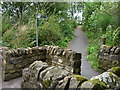
Entrance to Heritage Path
The small rectangular sign reads;
"Heritage Path
River Kelvin Walkway
The walkway follows an old mineral
railway which formed part of an extensive
system of lines that connected the
Twechar pits, Dumbreck pit, Kilsyth,
Auchinstarry quarry and several gravel pits.
Small railway engines called pugs hauled
trains of tubs containing coal, ironstone,
mine waste, quarry stone, coke and gravel.
Built in stages from the 1860's it was used
until the 1960's."
Image: © Texas Radio and The Big Beat
Taken: 15 Sep 2012
0.08 miles
10
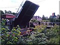
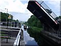
Twechar Bridge Opening
It takes 2 British Waterways employees to do this for through navigation but to the naked eye the clearance available doesn't require opening the bridge for a barge.
Image: © Robert Murray
Taken: 17 Jun 2007
0.08 miles