IMAGES TAKEN NEAR TO
Queenzieburn, Kilsyth, GLASGOW, G65 9LF
Introduction
This page details the photographs taken nearby to G65 9LF by members of the Geograph project.
The Geograph project started in 2005 with the aim of publishing, organising and preserving representative images for every square kilometre of Great Britain, Ireland and the Isle of Man.

There are currently over 7.5m images from over14,400 individuals and you can help contribute to the project by visiting https://www.geograph.org.uk
Image Map
Images are licensed for reuse under creativecommons.org/licenses/by-sa/2.0
Notes
- Clicking on the map will re-center to the selected point.
- The higher the marker number, the further away the image location is from the centre of the postcode.
Image Listing (3 Images Found)
Images are licensed for reuse under creativecommons.org/licenses/by-sa/2.0
Image
Details
Distance
1
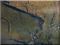
Burnhead from the air
On the course of the Corrie Burn.
Image: © Thomas Nugent
Taken: 11 Dec 2017
0.23 miles
2
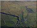
The Corrie Burn glen from the air
The gorge casts a shadow across the burn. Burnhead farm is at the bottom of the photo, with Cairnbog Farm to the right.
Image: © Thomas Nugent
Taken: 4 Dec 2016
0.24 miles
3
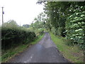
Tree and hedge enclosed minor road near to Burnhead Farm
Looking south-westward.
Image: © Peter Wood
Taken: 3 Sep 2022
0.25 miles