IMAGES TAKEN NEAR TO
Haugh Road, GLASGOW, G65 9JW
Introduction
This page details the photographs taken nearby to Haugh Road, G65 9JW by members of the Geograph project.
The Geograph project started in 2005 with the aim of publishing, organising and preserving representative images for every square kilometre of Great Britain, Ireland and the Isle of Man.

There are currently over 7.5m images from over14,400 individuals and you can help contribute to the project by visiting https://www.geograph.org.uk
Image Map
Images are licensed for reuse under creativecommons.org/licenses/by-sa/2.0
Notes
- Clicking on the map will re-center to the selected point.
- The higher the marker number, the further away the image location is from the centre of the postcode.
Image Listing (30 Images Found)
Images are licensed for reuse under creativecommons.org/licenses/by-sa/2.0
Image
Details
Distance
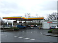
5
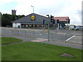
Lidl supermarket, Airdrie Road, Kilsyth
The tower of the Burns and Old Parish Church overlooks the scene.
Image: © Jonathan Billinger
Taken: 17 Jul 2007
0.15 miles
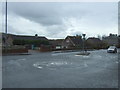
6

Carpark of Lidl and Home Bargains, Kilsyth
Image: © Steven Brown
Taken: 4 Aug 2024
0.15 miles
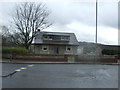
7
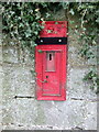
Disused Victorian postbox on Glasgow Road, Kilsyth
Image: © JThomas
Taken: 30 Mar 2017
0.16 miles
8
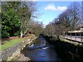
The Garrel Burn, Kilsyth
Flowing between high built up banks near Backbrae Street.
Image: © Robert Murray
Taken: 12 Feb 2010
0.19 miles
9
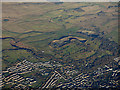
Kilsyth from the air
Kilsyth Lennox Golf Club and the Beltmoss quarries can also be seen.
Image: © Thomas Nugent
Taken: 4 Dec 2016
0.20 miles
10
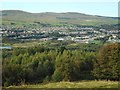
Kilsyth
Seen from the top of Bar Hill. The Kilsyth Hills are behind the town.
Image: © Richard Sutcliffe
Taken: 18 Sep 2020
0.21 miles