IMAGES TAKEN NEAR TO
Hillside, GLASGOW, G65 9HL
Introduction
This page details the photographs taken nearby to Hillside, G65 9HL by members of the Geograph project.
The Geograph project started in 2005 with the aim of publishing, organising and preserving representative images for every square kilometre of Great Britain, Ireland and the Isle of Man.

There are currently over 7.5m images from over14,400 individuals and you can help contribute to the project by visiting https://www.geograph.org.uk
Image Map
Images are licensed for reuse under creativecommons.org/licenses/by-sa/2.0
Notes
- Clicking on the map will re-center to the selected point.
- The higher the marker number, the further away the image location is from the centre of the postcode.
Image Listing (7 Images Found)
Images are licensed for reuse under creativecommons.org/licenses/by-sa/2.0
Image
Details
Distance
1
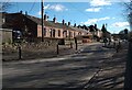
Miners' Row: Croy
With one of several traffic control chicanes
Image: © Jim Smillie
Taken: 7 Mar 2023
0.08 miles
2
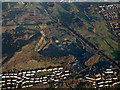
Croy Quarry from the air
An aggregates quarry at Croy, beside the main Glasgow to Edinburgh railway line.
Image: © Thomas Nugent
Taken: 8 Dec 2017
0.12 miles
3
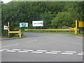
Entrance to Croy Quarry
The entrance to Croy Quarry on the B802, between Cumbernauld, Auchinstarry and Kilsyth.
Image: © Renata Edge
Taken: 17 Aug 2008
0.20 miles
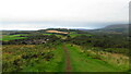
4
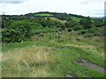
Descending off Croy Hill
Following a path off the hill, to reach a road just to the north of the village of Croy.
Image: © Chris Heaton
Taken: 10 Aug 2009
0.21 miles
5
What's left of the Antonine Wall
The ditch through which the Wall ran, almost two thousand years ago.
Image: © Stephen Sweeney
Taken: 7 Feb 2012
0.22 miles
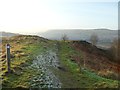
6
On John Muir Way - path descending west from Croy Hill
Image: © Colin Park
Taken: 22 Sep 2021
0.22 miles
7
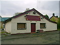
The Croy Tavern
The Croy Tavern has not been trading for a couple of years and has evidently suffered from a combination of neglect and vandalism since it closed.
Image: © Mark Nightingale
Taken: 20 Oct 2009
0.25 miles