IMAGES TAKEN NEAR TO
Anderson Crescent, GLASGOW, G65 9EW
Introduction
This page details the photographs taken nearby to Anderson Crescent, G65 9EW by members of the Geograph project.
The Geograph project started in 2005 with the aim of publishing, organising and preserving representative images for every square kilometre of Great Britain, Ireland and the Isle of Man.

There are currently over 7.5m images from over14,400 individuals and you can help contribute to the project by visiting https://www.geograph.org.uk
Image Map
Images are licensed for reuse under creativecommons.org/licenses/by-sa/2.0
Notes
- Clicking on the map will re-center to the selected point.
- The higher the marker number, the further away the image location is from the centre of the postcode.
Image Listing (40 Images Found)
Images are licensed for reuse under creativecommons.org/licenses/by-sa/2.0
Image
Details
Distance
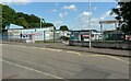
1
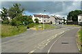
Queenzieburn
Dykehead Road leads off to the left.
Image: © Richard Sutcliffe
Taken: 13 Jul 2021
0.06 miles
2
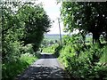
Doon the brae tae' Queenieburn
Dykehead Road looking down toward the village of Queenieburn - or in english, Queenzieburn.
Image: © Robert Murray
Taken: 3 Jun 2010
0.07 miles
3
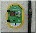
Defibrillator, Queenzieburn
On the wall of Queenzieburn Hall Image
Image: © Richard Sutcliffe
Taken: 13 Jul 2021
0.09 miles
4
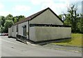
Queenzieburn Hall
Community hall, used for various functions and events.
Image: © Richard Sutcliffe
Taken: 13 Jul 2021
0.10 miles
5
Chapelgreen Primary School
In Queenzieburn.
Image: © Richard Sutcliffe
Taken: 13 Jul 2021
0.10 miles
6
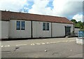
Queenzieburn Hall
Community hall, used for various functions and events.
Image: © Richard Sutcliffe
Taken: 13 Jul 2021
0.10 miles
7
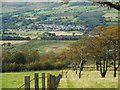
Queenzieburn
Seen from the edge of Bar Hill.
Image: © Richard Sutcliffe
Taken: 18 Sep 2020
0.11 miles
8
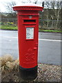
George VI postbox on Mill Road, Queenzieburn
Postbox No. G65 277.
See Image] for context.
Image: © JThomas
Taken: 30 Mar 2017
0.11 miles
9
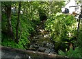
Queenzie Burn
Running behind Queenzieburn Hall.
Image: © Richard Sutcliffe
Taken: 13 Jul 2021
0.12 miles
10
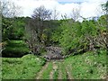
Ford across the Queenzie Burn
Just to the N.W. of the village. This location is also the confluence of the two burns that become the Queenzie Burn.
Image: © Robert Murray
Taken: 15 May 2010
0.12 miles