IMAGES TAKEN NEAR TO
Mill Road, GLASGOW, G65 9EF
Introduction
This page details the photographs taken nearby to Mill Road, G65 9EF by members of the Geograph project.
The Geograph project started in 2005 with the aim of publishing, organising and preserving representative images for every square kilometre of Great Britain, Ireland and the Isle of Man.

There are currently over 7.5m images from over14,400 individuals and you can help contribute to the project by visiting https://www.geograph.org.uk
Image Map
Images are licensed for reuse under creativecommons.org/licenses/by-sa/2.0
Notes
- Clicking on the map will re-center to the selected point.
- The higher the marker number, the further away the image location is from the centre of the postcode.
Image Listing (29 Images Found)
Images are licensed for reuse under creativecommons.org/licenses/by-sa/2.0
Image
Details
Distance
1
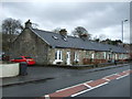
Mill Road, Queenzieburn
Showing position of Postbox No. G65 277.
See Image] for postbox.
Image: © JThomas
Taken: 30 Mar 2017
0.03 miles
3
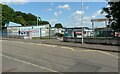
Chapelgreen Primary School
In Queenzieburn.
Image: © Richard Sutcliffe
Taken: 13 Jul 2021
0.06 miles
4
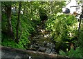
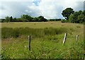
Queenzie Burn
Running behind Queenzieburn Hall.
Image: © Richard Sutcliffe
Taken: 13 Jul 2021
0.06 miles
5
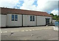
Queenzieburn Hall
Community hall, used for various functions and events.
Image: © Richard Sutcliffe
Taken: 13 Jul 2021
0.07 miles
6
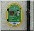
Defibrillator, Queenzieburn
On the wall of Queenzieburn Hall Image
Image: © Richard Sutcliffe
Taken: 13 Jul 2021
0.07 miles
7
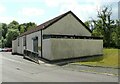
Queenzieburn Hall
Community hall, used for various functions and events.
Image: © Richard Sutcliffe
Taken: 13 Jul 2021
0.07 miles
9
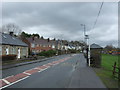
Bus stop and shelter on Kilsyth Road (A803), Queenzieburn
Image: © JThomas
Taken: 30 Mar 2017
0.09 miles