IMAGES TAKEN NEAR TO
Gavell Road, GLASGOW, G65 9BS
Introduction
This page details the photographs taken nearby to Gavell Road, G65 9BS by members of the Geograph project.
The Geograph project started in 2005 with the aim of publishing, organising and preserving representative images for every square kilometre of Great Britain, Ireland and the Isle of Man.

There are currently over 7.5m images from over14,400 individuals and you can help contribute to the project by visiting https://www.geograph.org.uk
Image Map
Images are licensed for reuse under creativecommons.org/licenses/by-sa/2.0
Notes
- Clicking on the map will re-center to the selected point.
- The higher the marker number, the further away the image location is from the centre of the postcode.
Image Listing (4 Images Found)
Images are licensed for reuse under creativecommons.org/licenses/by-sa/2.0
Image
Details
Distance
1
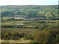
Queenzieburn and Queenzieburn Industrial Estate
Seen from Bar Hill. Top left is Queenzieburn. On the right is the Queenzieburn Industrial Estate. The small loch in the centre is part of Dumbreck Local Nature Reserve.
Image: © Richard Sutcliffe
Taken: 18 Sep 2020
0.19 miles
2
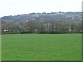
Kelvin Valley Railway
The line of the causeway which carried the line across the flood plain. Castle Hill Iron Age and Barr Hill Roman forts sit above.
Image: © Robert Murray
Taken: 24 Apr 2010
0.19 miles
3
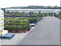
Craigmarloch Nurseries, Kilsyth
One of the largest wholesale nurseries in Scotland.
Image: © Jonathan Billinger
Taken: 17 Jul 2007
0.23 miles
4
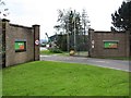
Industrial estate, Kilsyth
Entrance to Bam, a construction company.
Image: © Richard Webb
Taken: 30 Sep 2011
0.23 miles