IMAGES TAKEN NEAR TO
Northfield Road, GLASGOW, G65 9BA
Introduction
This page details the photographs taken nearby to Northfield Road, G65 9BA by members of the Geograph project.
The Geograph project started in 2005 with the aim of publishing, organising and preserving representative images for every square kilometre of Great Britain, Ireland and the Isle of Man.

There are currently over 7.5m images from over14,400 individuals and you can help contribute to the project by visiting https://www.geograph.org.uk
Image Map
Images are licensed for reuse under creativecommons.org/licenses/by-sa/2.0
Notes
- Clicking on the map will re-center to the selected point.
- The higher the marker number, the further away the image location is from the centre of the postcode.
Image Listing (16 Images Found)
Images are licensed for reuse under creativecommons.org/licenses/by-sa/2.0
Image
Details
Distance
1
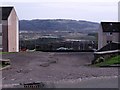
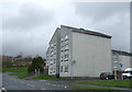
Empty car park, Kilsyth
Northfield area with Dumbreck Marsh and Castle Hill in the distance.
Image: © Robert Murray
Taken: 24 Apr 2010
0.10 miles
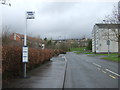
2
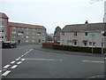
John Wilson Drive, Kilsyth
Amid a light flurry of snow - just days after Scotland's warmest March on record came to an end.
Image: © Stephen Sweeney
Taken: 3 Apr 2012
0.10 miles
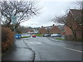
4
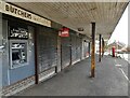
Closed shops
Several of the shop units beside the roundabout on Balmalloch Road are closed.
The pillar box is postbox number G65 1163D.
Image: © Richard Sutcliffe
Taken: 31 Mar 2022
0.17 miles
7
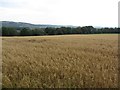
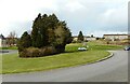
Oats, Balcastle Road
A field of oats on the west side of Balcastle Road.
Image: © Richard Webb
Taken: 30 Sep 2011
0.19 miles
9
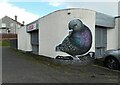
Big Mad Pigeon
Mural on the side of The Broch bar in Kilsyth.
Image: © Richard Sutcliffe
Taken: 31 Mar 2022
0.20 miles
10
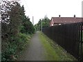
Disused railway, Kilsyth
Now a path, this was once a mineral line running above Kilsyth towards Colzium.
Image: © Richard Webb
Taken: 30 Sep 2011
0.20 miles