IMAGES TAKEN NEAR TO
Tak-Ma-Doon Road, GLASGOW, G65 0RY
Introduction
This page details the photographs taken nearby to Tak-Ma-Doon Road, G65 0RY by members of the Geograph project.
The Geograph project started in 2005 with the aim of publishing, organising and preserving representative images for every square kilometre of Great Britain, Ireland and the Isle of Man.

There are currently over 7.5m images from over14,400 individuals and you can help contribute to the project by visiting https://www.geograph.org.uk
Image Map
Images are licensed for reuse under creativecommons.org/licenses/by-sa/2.0
Notes
- Clicking on the map will re-center to the selected point.
- The higher the marker number, the further away the image location is from the centre of the postcode.
Image Listing (7 Images Found)
Images are licensed for reuse under creativecommons.org/licenses/by-sa/2.0
Image
Details
Distance
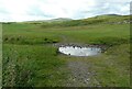
2
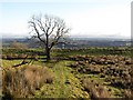
Track in a field
A causeway raised above wetter land on either side.
Image: © Richard Webb
Taken: 27 Jan 2012
0.08 miles
3
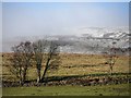
Tak-ma-doon Road
Trees beside the road which attacks the formidable Kilsyth/Campsie scarp, crossing to the Carron Valley.
Image: © Richard Webb
Taken: 27 Jan 2012
0.08 miles
4
Stone gateposts
Remains of a gate on improved land off the Tak-ma-doon Road.
Image: © Richard Webb
Taken: 27 Jan 2012
0.13 miles
5

Gully at Brockieside
From which the burn featured in www.geograph.org.uk/photo/1848425 flows through.
Image: © Robert Murray
Taken: 8 May 2010
0.16 miles

7
Ford on rough track
The track only goes about 100m before crossing another burn and then fizzling out.
Image: © Richard Sutcliffe
Taken: 13 Jul 2021
0.24 miles