IMAGES TAKEN NEAR TO
Valleybank, GLASGOW, G65 0RH
Introduction
This page details the photographs taken nearby to Valleybank, G65 0RH by members of the Geograph project.
The Geograph project started in 2005 with the aim of publishing, organising and preserving representative images for every square kilometre of Great Britain, Ireland and the Isle of Man.

There are currently over 7.5m images from over14,400 individuals and you can help contribute to the project by visiting https://www.geograph.org.uk
Image Map
Images are licensed for reuse under creativecommons.org/licenses/by-sa/2.0
Notes
- Clicking on the map will re-center to the selected point.
- The higher the marker number, the further away the image location is from the centre of the postcode.
Image Listing (70 Images Found)
Images are licensed for reuse under creativecommons.org/licenses/by-sa/2.0
Image
Details
Distance
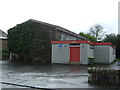
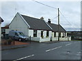
2
Banton Village Hall
Off Main Street, Banton.
Image: © Richard Sutcliffe
Taken: 18 Jun 2018
0.04 miles
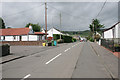
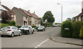
5

Banton
Seen from the Tak-ma-doon Road.
Image: © Richard Webb
Taken: 27 Jan 2012
0.06 miles
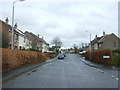
6
Mill Road, Banton
Seen from the junction with Valleybank.
Image: © Richard Sutcliffe
Taken: 18 Jun 2018
0.06 miles
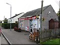
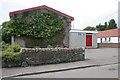
9
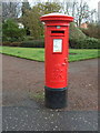
George VI postbox on Main Street, Banton
Postbox No. G65 1167.
See Image] for context.
Image: © JThomas
Taken: 30 Mar 2017
0.06 miles