IMAGES TAKEN NEAR TO
Banton, Kilsyth, GLASGOW, G65 0RA
Introduction
This page details the photographs taken nearby to G65 0RA by members of the Geograph project.
The Geograph project started in 2005 with the aim of publishing, organising and preserving representative images for every square kilometre of Great Britain, Ireland and the Isle of Man.

There are currently over 7.5m images from over14,400 individuals and you can help contribute to the project by visiting https://www.geograph.org.uk
Image Map
Images are licensed for reuse under creativecommons.org/licenses/by-sa/2.0
Notes
- Clicking on the map will re-center to the selected point.
- The higher the marker number, the further away the image location is from the centre of the postcode.
Image Listing (19 Images Found)
Images are licensed for reuse under creativecommons.org/licenses/by-sa/2.0
Image
Details
Distance
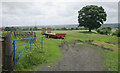
1

High Banton
Nice pic - pity about the bins.
Image: © Robert Murray
Taken: 30 Jan 2010
0.03 miles
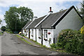
2

Row of Cottages, High Banton
There used to be around a dozen cottages which made up this row.
Image: © Texas Radio and The Big Beat
Taken: 19 Aug 2010
0.03 miles
5

High Banton
Picturesque cottages in the old village of Banton.
Image: © Stephen Sweeney
Taken: 4 Aug 2016
0.05 miles
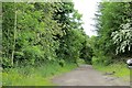
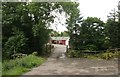
8
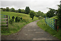
Gates, Glenhead
The road leads from Glenhead to High Banton.
Image: © Richard Sutcliffe
Taken: 18 Jun 2018
0.10 miles
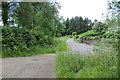
9

Glenhead Cottage
At High Banton in the Kilsyth foothills.
Image: © Robert Murray
Taken: 30 Jan 2010
0.10 miles