IMAGES TAKEN NEAR TO
Lammerknowes Road, GLASGOW, G65 0QT
Introduction
This page details the photographs taken nearby to Lammerknowes Road, G65 0QT by members of the Geograph project.
The Geograph project started in 2005 with the aim of publishing, organising and preserving representative images for every square kilometre of Great Britain, Ireland and the Isle of Man.

There are currently over 7.5m images from over14,400 individuals and you can help contribute to the project by visiting https://www.geograph.org.uk
Image Map
Images are licensed for reuse under creativecommons.org/licenses/by-sa/2.0
Notes
- Clicking on the map will re-center to the selected point.
- The higher the marker number, the further away the image location is from the centre of the postcode.
Image Listing (69 Images Found)
Images are licensed for reuse under creativecommons.org/licenses/by-sa/2.0
Image
Details
Distance
1
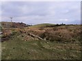
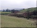
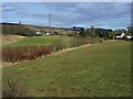
The ditch and the Meadows
The headwater of the Kelvin in a straight line south east of Banton.
Image: © Robert Murray
Taken: 18 Feb 2010
0.04 miles
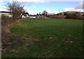
2
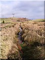
Headwaters of the Kelvin
On the very south east perimeter of Banton. This drainage ditch polluted by ochre from mine workings is the head waters of 'Glasgow's other river'.
See also www.geograph.org.uk/photo/1716279
Image: © Robert Murray
Taken: 18 Feb 2010
0.05 miles
3
Lammerknowes
Track from Banton to Lammerknowes farm.
Image: © Robert Murray
Taken: 18 Feb 2010
0.06 miles
4
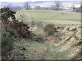
Source of the Kelvin
The water in this ditch - discoloured by ochre - can be seen to be flowing (slowly) out of an agricultural drainage pipe - draining the fields known as the 'Meadows' to Bantonians.
This is the highest point of water that constitutes the burn then water and finally river Kelvin - it can safely then be claimed to be the modern source of that river.
Bill Gracie, a life long Bantonian in his History of Banton, published in 1995 has this to say on the subject.
"The river Kelvin rises in Banton from a marshy area near Lammerknowes (farm, now demolished) from where it flows beneath the tennis courts and the village before turning south and passing under the parish church grounds on its way to Kelvihead where it is piped under the A803." See related photo www.geograph.org.uk/photo/1716256
Let there be no more claims of this river rising in Dullatur bog.
Image: © Robert Murray
Taken: 18 Feb 2010
0.06 miles
5
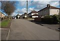
Houses: Mailings Road Banton
An eastward expansion of original village
Image: © Jim Smillie
Taken: 7 Mar 2023
0.08 miles
6
Laigh boggy ground
Situated in the low - or 'laigh' in Scots - land between two higher lands.
Image: © Robert Murray
Taken: 18 Feb 2010
0.09 miles
7
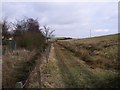
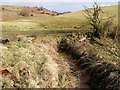
Track beside the ditch
That is the river Kelvin - in its infant form.
Image: © Robert Murray
Taken: 18 Feb 2010
0.09 miles
8
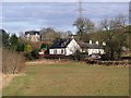
Mailings
A hamlet of one house and a row of ploughman's cottages N.E. of Banton. Medowside farmhouse sits on the horizon.
Image: © Robert Murray
Taken: 13 Feb 2010
0.12 miles
9
Line of Craigdouffie Burn
It flows south-west from Mailings towards Banton.
Image: © Robert Murray
Taken: 13 Feb 2010
0.12 miles
10
Cottages at Mailings
These cottages appear on 1860's map
Image: © Jim Smillie
Taken: 7 Mar 2023
0.13 miles