IMAGES TAKEN NEAR TO
Banton, Kilsyth, GLASGOW, G65 0QL
Introduction
This page details the photographs taken nearby to G65 0QL by members of the Geograph project.
The Geograph project started in 2005 with the aim of publishing, organising and preserving representative images for every square kilometre of Great Britain, Ireland and the Isle of Man.

There are currently over 7.5m images from over14,400 individuals and you can help contribute to the project by visiting https://www.geograph.org.uk
Image Map
Images are licensed for reuse under creativecommons.org/licenses/by-sa/2.0
Notes
- Clicking on the map will re-center to the selected point.
- The higher the marker number, the further away the image location is from the centre of the postcode.
Image Listing (42 Images Found)
Images are licensed for reuse under creativecommons.org/licenses/by-sa/2.0
Image
Details
Distance
1
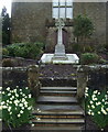
War memorial in front of Banton Parish Church
Image: © JThomas
Taken: 30 Mar 2017
0.01 miles
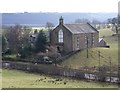
2
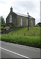
Banton Parish Church
Built in 1838 as a ‘chapel of ease’ beside Kelvinhead Road.
Image: © Richard Sutcliffe
Taken: 18 Jun 2018
0.02 miles
4
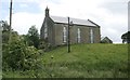
Banton Parish Church
Built in 1838 as a ‘chapel of ease’.
Image: © Richard Sutcliffe
Taken: 18 Jun 2018
0.02 miles
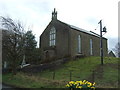
5
Banton Parish Church
Church of Scotland i.e. Presbyterian faith.
Image: © Robert Murray
Taken: 18 Feb 2010
0.02 miles
6
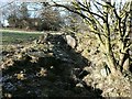
Kelvin Water
The burn comes to the surface from the boulders at the western side of the Kelvinhead to Banton road about 30m south of the boundary wall of Banton Kirk.
Image: © Robert Murray
Taken: 30 Jan 2010
0.04 miles
7
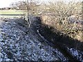
Headwaters of the Kelvin
Making a decent cut through the land even though it has just surfaced.
Image: © Robert Murray
Taken: 30 Jan 2010
0.07 miles
8
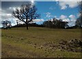
Tree in field beside Kelvinhead Road
Bare branches clearly visible against sky
Image: © Jim Smillie
Taken: 7 Mar 2023
0.07 miles
9
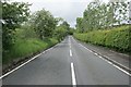
Kelvinhead Road
Looking towards Banton.
Image: © Richard Sutcliffe
Taken: 18 Jun 2018
0.07 miles
10
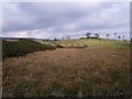
Gorse, bog and hill
The straight line in the centre of the bog between the gorse on the left and the rise of ground on the right is the ditch that is the very, very upper river Kelvin. The Banton to Kelvinhead road is behind the hedge.
Image: © Robert Murray
Taken: 18 Feb 2010
0.07 miles