IMAGES TAKEN NEAR TO
Colzium, GLASGOW, G65 0PY
Introduction
This page details the photographs taken nearby to Colzium, G65 0PY by members of the Geograph project.
The Geograph project started in 2005 with the aim of publishing, organising and preserving representative images for every square kilometre of Great Britain, Ireland and the Isle of Man.

There are currently over 7.5m images from over14,400 individuals and you can help contribute to the project by visiting https://www.geograph.org.uk
Image Map
Images are licensed for reuse under creativecommons.org/licenses/by-sa/2.0
Notes
- Clicking on the map will re-center to the selected point.
- The higher the marker number, the further away the image location is from the centre of the postcode.
Image Listing (62 Images Found)
Images are licensed for reuse under creativecommons.org/licenses/by-sa/2.0
Image
Details
Distance
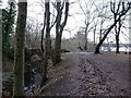
1
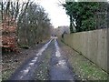
Woodland walk
This was originally the trackbed of the old tramway c.1850s onwards which ran from the Forth & Clyde Canal near Craigmarloch bridge up to the ironstone and coal pits at Riskend.
Image: © Robert Murray
Taken: 10 Feb 2010
0.04 miles
4
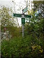
Finger post, Barton Loch Path
Left to Colzium House (½ mile); right to Banton (1 mile); or back to Kilsyth Town Centre (1½ miles) or Auchinatarry & canal (1¾ miles).
Image: © Richard Sutcliffe
Taken: 29 Aug 2020
0.08 miles
5
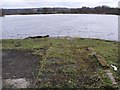
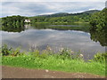
Boat Ramp, Townhead Reservoir
Remains of. No boats are ever to be seen on this body of water - by order of the local angling club.
Image: © Robert Murray
Taken: 23 Mar 2010
0.10 miles
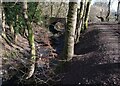
6
Colzium Estate, bridge to Riskend farm
With the canal feeder to the left and Townhead Reservoir ahead.
Image: © Robert Murray
Taken: 21 Jan 2010
0.10 miles
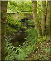
7
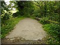
Bridge over canal feeder
The bridge crosses a section of lade which supplies water from the Garrell Burn to the west into Banton Loch. This was built to maintain water levels to feed the nearby Forth and Clyde Canal. Although the road over the bridge is wide and metalled, it changes into a narrow track on the other side.
Image: © Richard Sutcliffe
Taken: 29 Aug 2020
0.10 miles
8
Stream: Colzium Estate
Identified as a canal feeder
Image: © Jim Smillie
Taken: 7 Mar 2023
0.10 miles
9
Bridge over canal feeder
The bridge crosses a section of lade which supplies water from the Garrell Burn to the west into Banton Loch. This was built to maintain water levels to feed the nearby Forth and Clyde Canal.
Image: © Richard Sutcliffe
Taken: 29 Aug 2020
0.10 miles
10
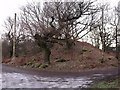
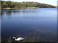
Castle Hill Motte
Over looks the south east corner of Townhead Reservoir.
Image: © Robert Murray
Taken: 21 Jan 2010
0.11 miles