IMAGES TAKEN NEAR TO
Findlay Street, GLASGOW, G65 0ND
Introduction
This page details the photographs taken nearby to Findlay Street, G65 0ND by members of the Geograph project.
The Geograph project started in 2005 with the aim of publishing, organising and preserving representative images for every square kilometre of Great Britain, Ireland and the Isle of Man.

There are currently over 7.5m images from over14,400 individuals and you can help contribute to the project by visiting https://www.geograph.org.uk
Image Map
Images are licensed for reuse under creativecommons.org/licenses/by-sa/2.0
Notes
- Clicking on the map will re-center to the selected point.
- The higher the marker number, the further away the image location is from the centre of the postcode.
Image Listing (93 Images Found)
Images are licensed for reuse under creativecommons.org/licenses/by-sa/2.0
Image
Details
Distance
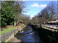
1
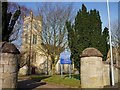
Kilsyth Burns & Old Parish Church
Image: © Texas Radio and The Big Beat
Taken: 20 Feb 2010
0.04 miles
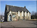
2
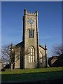
Kilsyth Burns & Old Parish Church
Image: © Texas Radio and The Big Beat
Taken: 20 Feb 2010
0.05 miles
3
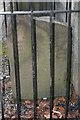
Francis Gordon's gravestone, Kilsyth Burns and Old Parish Church
Rear of the gravestone to Francis Gordon, a Covenanting soldier who fled the Battle of Kilsyth on his horse, but was seen by one of Montrose's soldiers and killed. The Battle of Kilsyth took place in 1645 however, but the inscription states it took place in 1646 - did they simply get it wrong?
The inscription reads:
THERE IS A CONSTANT
TRADITION THAT THIS STONE
MARKED THE GRAVE OF
FRANCIS GORDON, CADET OF
A NOBLE COVENANTING FAMILY
WHO FLEEING FROM THE BATTLE
OF KILSYTH - FOUGHT 16TH
AUGUST 1646 - WAS OVERTAKEN
AND SLAIN BY ONE OF MONTROSE
CLANSMEN AT BONNYFOOT BRIDGE
DENNY, THE KILSYTH KIRK SESSION
WITH THE AUTHORITY OF THE
COUNTY COUNCIL REMOVED
THE STONE TO THIS PARISH
FEBY 1892
For detail of front of stone, see http://www.geograph.org.uk/photo/2177754 and for photo of Burns and Old Parish Church, see http://www.geograph.org.uk/photo/1718181
Image: © Becky Williamson
Taken: 13 Feb 2010
0.07 miles
4
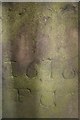
Detail of Francis Gordon's gravestone, Kilsyth Burns and Old Parish Church
Front of the gravestone to Francis Gordon, a Covenanting soldier who fled the Battle of Kilsyth on his horse, but was seen by one of Montrose's soldiers and killed. The Battle of Kilsyth took place in 1645 however, so why is Gordon's gravestone inscribed 1646?
For photo of rear of stone, see http://www.geograph.org.uk/photo/2177757 and for photo of Kilsyth Burns and Old Parish Church, see http://www.geograph.org.uk/photo/1718181
Image: © Becky Williamson
Taken: 13 Feb 2010
0.07 miles
5
The Garrel Burn, Kilsyth
Flowing between high built up banks near Backbrae Street.
Image: © Robert Murray
Taken: 12 Feb 2010
0.07 miles
6
Kilsyth Methodist Church
This building has since been demolished.
Image: © Texas Radio and The Big Beat
Taken: 20 Feb 2010
0.07 miles
7

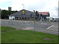
Carpark of Lidl and Home Bargains, Kilsyth
Image: © Steven Brown
Taken: 4 Aug 2024
0.09 miles
8
Lidl supermarket, Airdrie Road, Kilsyth
The tower of the Burns and Old Parish Church overlooks the scene.
Image: © Jonathan Billinger
Taken: 17 Jul 2007
0.11 miles
9
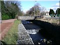
The Garrel Burn, Kilsyth
Weir and pedestrian footbridge near St.Patrick's School.
Image: © Robert Murray
Taken: 12 Feb 2010
0.12 miles
10

Main Street, Kilsyth
Pedestrianised with several vacant shops at the northern end.
Image: © Richard Webb
Taken: 2 May 2014
0.14 miles