IMAGES TAKEN NEAR TO
Fisher Avenue, GLASGOW, G65 0LT
Introduction
This page details the photographs taken nearby to Fisher Avenue, G65 0LT by members of the Geograph project.
The Geograph project started in 2005 with the aim of publishing, organising and preserving representative images for every square kilometre of Great Britain, Ireland and the Isle of Man.

There are currently over 7.5m images from over14,400 individuals and you can help contribute to the project by visiting https://www.geograph.org.uk
Image Map
Images are licensed for reuse under creativecommons.org/licenses/by-sa/2.0
Notes
- Clicking on the map will re-center to the selected point.
- The higher the marker number, the further away the image location is from the centre of the postcode.
Image Listing (53 Images Found)
Images are licensed for reuse under creativecommons.org/licenses/by-sa/2.0
Image
Details
Distance
1
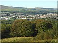
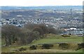
Kilsyth
Seen from the top of Bar Hill.
Image: © Richard Sutcliffe
Taken: 18 Sep 2020
0.03 miles
2
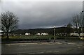
Bogside Park, Kilsyth
The park is seen looking across Howe Road from Johnston Avenue.
Image: © Alec MacKinnon
Taken: 17 Mar 2022
0.05 miles
3
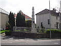
Memorial for The Rev. Dr. William Jeffrey
Image: © Stevie Spiers
Taken: 17 May 2009
0.06 miles
4
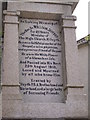
Memorial inscription for The Rev. Dr. William Jeffrey
Image: © Stevie Spiers
Taken: 17 May 2009
0.06 miles
5
Kilsyth from the north
Viewed from the hills above the town.
Image: © Richard Sutcliffe
Taken: 31 Mar 2022
0.06 miles
6
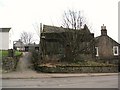
Burns Church (derelict)
United Free High Church (later Burns Church), Howe Road.
Now demolished www.geograph.org.uk/photo/1946597
Image: © Texas Radio and The Big Beat
Taken: 13 Feb 2010
0.07 miles
7
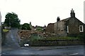
Burns Church (demolished)
Given it's sorry and dilapidated state, perhaps this building
was beyond saving www.geograph.org.uk/photo/1706739
Image: © Texas Radio and The Big Beat
Taken: 4 Jul 2010
0.08 miles
8
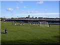
Duncansfield Park, Kilsyth. Football ground
Duncansfield Park, home of Kilsyth Rangers FC. Looking east.
Image: © paul c
Taken: 20 Feb 2004
0.13 miles
9
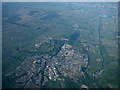
Kilsyth from the air
With the Forth & Clyde Canal running the length of the photo on the right.
Image: © Thomas Nugent
Taken: 5 Jun 2016
0.13 miles
10
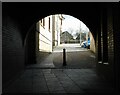
Looking through the archway
Looking along a passageway from Market Street towards U.P. Road. The road gets its name from being the original location of the United Presbyterian Church in Kilsyth.
Image: © Richard Sutcliffe
Taken: 31 Mar 2022
0.14 miles