IMAGES TAKEN NEAR TO
Blenheim Court, GLASGOW, G65 0JN
Introduction
This page details the photographs taken nearby to Blenheim Court, G65 0JN by members of the Geograph project.
The Geograph project started in 2005 with the aim of publishing, organising and preserving representative images for every square kilometre of Great Britain, Ireland and the Isle of Man.

There are currently over 7.5m images from over14,400 individuals and you can help contribute to the project by visiting https://www.geograph.org.uk
Image Map
Images are licensed for reuse under creativecommons.org/licenses/by-sa/2.0
Notes
- Clicking on the map will re-center to the selected point.
- The higher the marker number, the further away the image location is from the centre of the postcode.
Image Listing (120 Images Found)
Images are licensed for reuse under creativecommons.org/licenses/by-sa/2.0
Image
Details
Distance
1
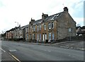
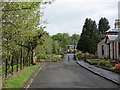
Houses on Kingston Road
Blenheim Court is to the right.
Image: © Richard Sutcliffe
Taken: 31 Mar 2022
0.05 miles
2
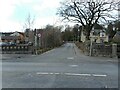
Tak-Ma-Doon Road
The road leads from here (junction with the A803, Stirling Road) to Carron Bridge, where it meets the B818.
Image: © Richard Sutcliffe
Taken: 31 Mar 2022
0.07 miles
3
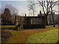
Auld Man's Rest
A place where the older gentry of Kilsyth used to meet to chat n' chill.
Now used by young men to partake of the fortified wine.
Image: © Texas Radio and The Big Beat
Taken: 20 Feb 2010
0.07 miles
4
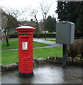
George V postbox on Stirling Road, Kilsyth
Postbox No. G65 387.
See Image] for context.
Image: © JThomas
Taken: 30 Mar 2017
0.07 miles
5
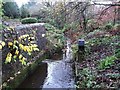
Kilsyth, canal feeder
On the east side of the Tak-Me-doon road. From here it flows to the Colzium Estate and thence into Banton Loch/Townhead Reservoir from where it takes a south westerly course to empty into the Forth & Clyde Canal at Craigmarloch bridge.
Image: © Robert Murray
Taken: 23 Nov 2009
0.08 miles
6
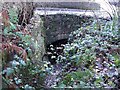
Kilsyth, old mill race
Now used solely as a canal feeder to the Forth & Clyde Canal. This is the water going under the Tak-Me-Doon road up the brae from Kilsyth town. To the left on this photo is where the mill water wheel would have been situated.
Image: © Robert Murray
Taken: 23 Nov 2009
0.08 miles
7
Burngreen, Kilsyth
Residential street in Kilsyth, beside the Garrel Burn. It has been blocked off at one end.
Image: © Richard Webb
Taken: 2 May 2014
0.09 miles
8
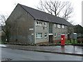
Houses on Stirling Road, Kilsyth
Showing position of Postbox No. G65 387.
See Image] for postbox.
Image: © JThomas
Taken: 30 Mar 2017
0.09 miles
9
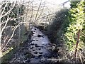
The Garrel Burn, Burnbank Terrace, Kilsyth
Sneaking its way towards the centre of the town.
Image: © Robert Murray
Taken: 10 Feb 2010
0.09 miles
10
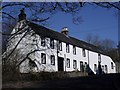
Old corn mill, Kilsyth
The Garrel mill on the Tak-Ma-Doon Road. This building is spread across two squares, the nearest part being in the same as the photographer.
Image: © Robert Murray
Taken: 22 Feb 2010
0.10 miles