IMAGES TAKEN NEAR TO
Monieburgh Road, GLASGOW, G65 0JB
Introduction
This page details the photographs taken nearby to Monieburgh Road, G65 0JB by members of the Geograph project.
The Geograph project started in 2005 with the aim of publishing, organising and preserving representative images for every square kilometre of Great Britain, Ireland and the Isle of Man.

There are currently over 7.5m images from over14,400 individuals and you can help contribute to the project by visiting https://www.geograph.org.uk
Image Map (Loading...)


Getting Data...Please wait
Leaflet Map data © OpenStreetMap
Images are licensed for reuse under creativecommons.org/licenses/by-sa/2.0
Notes
- Clicking on the map will re-center to the selected point.
- The higher the marker number, the further away the image location is from the centre of the postcode.
Image Listing (51 Images Found)
Images are licensed for reuse under creativecommons.org/licenses/by-sa/2.0
Image
Details
Distance

5
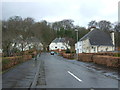
Traffic lights, Stirling Road
Looking from Burngreen Brae towards the A803, Stirling Road.
Image: © Richard Sutcliffe
Taken: 18 Jun 2018
0.07 miles
6
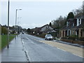
Stirling Road (A803), Kilsyth
Looking east.
Image: © JThomas
Taken: 30 Mar 2017
0.10 miles
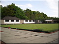
7
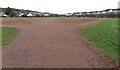
Recreation ground
A red blaes pitch beside Burngreen Community Centre.
Image: © Richard Sutcliffe
Taken: 31 Mar 2022
0.10 miles

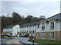
9
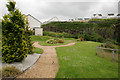
Green space, Burngreen Brae
Burngreen Brae is a new development by Dawn Homes.
Image: © Richard Sutcliffe
Taken: 18 Jun 2018
0.13 miles
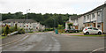
10
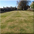
Putting Green: Burngreen Park
Looks like any open grassy area but there were pins marking the holes
Image: © Jim Smillie
Taken: 22 Apr 2022
0.13 miles