IMAGES TAKEN NEAR TO
Craigbarnet Avenue, GLASGOW, G64 4LH
Introduction
This page details the photographs taken nearby to Craigbarnet Avenue, G64 4LH by members of the Geograph project.
The Geograph project started in 2005 with the aim of publishing, organising and preserving representative images for every square kilometre of Great Britain, Ireland and the Isle of Man.

There are currently over 7.5m images from over14,400 individuals and you can help contribute to the project by visiting https://www.geograph.org.uk
Image Map
Images are licensed for reuse under creativecommons.org/licenses/by-sa/2.0
Notes
- Clicking on the map will re-center to the selected point.
- The higher the marker number, the further away the image location is from the centre of the postcode.
Image Listing (13 Images Found)
Images are licensed for reuse under creativecommons.org/licenses/by-sa/2.0
Image
Details
Distance
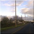
2
Torrance housing
Forth Road houses from Balmore Road.
Image: © Stephen Sweeney
Taken: 15 Jul 2009
0.08 miles
3
7.5 Tons weight limit, Tower Road
The weight limit refers to the bridge over the old railway line a few yards further up the road.
Image: © Richard Sutcliffe
Taken: 30 May 2015
0.09 miles
4
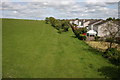
Route of the Kelvin Valley Railway line, Torrance
These houses on the edge of Torrance back on to what was the route of the Kelvin Valley Railway line, now part of the grassy field. The photograph was taken from the bridge which carries Tower Road over the route.
Image: © Richard Sutcliffe
Taken: 30 May 2015
0.09 miles
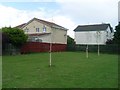
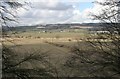
5
Edge of Torrance
The western side of the village, seen from Bargeny Hill grasslands.
Image: © Richard Sutcliffe
Taken: 12 Jun 2018
0.10 miles
6
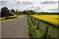
Tower Road, Torrance
Looking south down Tower Road to the junction with Balmore Road (A807). The field on the right is full of Oil Seed Rape.
Image: © Richard Sutcliffe
Taken: 30 May 2015
0.11 miles
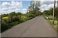
7
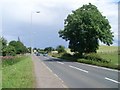
Approaching Torrance on the A807
From the west.
Image: © Stephen Sweeney
Taken: 15 Jul 2009
0.11 miles
8
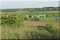
View from the canal
Looking from the Forth and Clyde Canal towards Glenside Farm and Tower Farm. Part of Torrance can be seen on the right, but most of the houses along Balmore Road (A807) are hidden by a low hill in between.
Image: © Richard Sutcliffe
Taken: 4 Mar 2020
0.18 miles
9
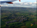
Torrance from the air
The River Kelvin can be seen meandering under Torrance Bridge in the foreground. Viewed from a Glasgow bound flight from Luton.
Image: © Thomas Nugent
Taken: 11 May 2012
0.19 miles
10
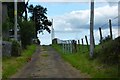
Track to Tower Farm
With watching moggie.
Image: © Robert Murray
Taken: 15 Jul 2015
0.22 miles