IMAGES TAKEN NEAR TO
Campbell Place, GLASGOW, G64 4HR
Introduction
This page details the photographs taken nearby to Campbell Place, G64 4HR by members of the Geograph project.
The Geograph project started in 2005 with the aim of publishing, organising and preserving representative images for every square kilometre of Great Britain, Ireland and the Isle of Man.

There are currently over 7.5m images from over14,400 individuals and you can help contribute to the project by visiting https://www.geograph.org.uk
Image Map
Images are licensed for reuse under creativecommons.org/licenses/by-sa/2.0
Notes
- Clicking on the map will re-center to the selected point.
- The higher the marker number, the further away the image location is from the centre of the postcode.
Image Listing (8 Images Found)
Images are licensed for reuse under creativecommons.org/licenses/by-sa/2.0
Image
Details
Distance
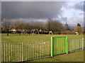
1
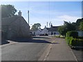
Balgochran
Entering from the south on West Balgochran Road.
Image: © Stephen Sweeney
Taken: 17 Jun 2010
0.16 miles
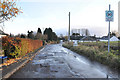
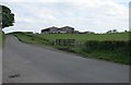
3
Across the Shaw Burn
Farmland near Bargrochan
Image: © Richard Webb
Taken: 31 May 2013
0.17 miles
4
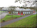
Torrance Primary School
Torrance Primary School is an open plan school consisting of three separate hexagonal buildings with adjoining corridors.
Image: © G Laird
Taken: 20 Nov 2010
0.19 miles
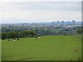
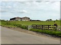
6
Farm buildings off Barraston Road
Image: © Richard Sutcliffe
Taken: 28 May 2016
0.22 miles
8
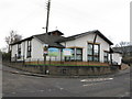
Torrance Parish Church
At the corner of School Road and West Balgrochan Road. http://www.torranceparishchurch.org.uk/
Image: © G Laird
Taken: 20 Nov 2010
0.25 miles