IMAGES TAKEN NEAR TO
Campsie Road, GLASGOW, G64 4EZ
Introduction
This page details the photographs taken nearby to Campsie Road, G64 4EZ by members of the Geograph project.
The Geograph project started in 2005 with the aim of publishing, organising and preserving representative images for every square kilometre of Great Britain, Ireland and the Isle of Man.

There are currently over 7.5m images from over14,400 individuals and you can help contribute to the project by visiting https://www.geograph.org.uk
Image Map
Images are licensed for reuse under creativecommons.org/licenses/by-sa/2.0
Notes
- Clicking on the map will re-center to the selected point.
- The higher the marker number, the further away the image location is from the centre of the postcode.
Image Listing (34 Images Found)
Images are licensed for reuse under creativecommons.org/licenses/by-sa/2.0
Image
Details
Distance
4
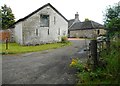
West Carlston Farm
On Campsie Road, Torrance.
Image: © Richard Sutcliffe
Taken: 31 Jul 2020
0.07 miles
5
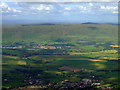
Torrance, Lennoxtown and the Campsie Fells from the air
Torrance is at the bottom of the photo and Lennoxtown can be seen nestling at the foot of the Campsie Fells. The Crow Road can just be seen to the left of Lennoxtown. A wind farm is prominent on the horizon, with another less prominent wind farm is on the left horizon in the far distance.
Viewed from a flight from a thundery Gatwick Image to Glasgow.
Image: © Thomas Nugent
Taken: 28 Jun 2011
0.08 miles
7
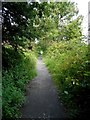
Old railway path
The path follows the route of the old Kelvin Valley Line, which ran from Kirkintilloch to Kilsyth and from there to Maryhill. The line opened in 1879, and closed in 1959.
Image: © Richard Sutcliffe
Taken: 31 Jul 2020
0.10 miles
8
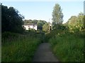
Following the dismantled railway line in Torrance
Just south of Park Crescent.
Image: © Stephen Sweeney
Taken: 5 Aug 2010
0.10 miles
9
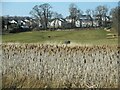
Houses, MacGillivray Avenue
Seen from the Torrance Railway Path. There is a large stand of Typha latifolia in a boggy area in the foreground.
Image: © Richard Sutcliffe
Taken: 8 Mar 2022
0.11 miles
10
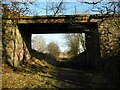
Bridge over the old railway line
This bridge over the former Kelvin Valley Railway (now the Torrance Railway Path) gave (and still gives) access from West Carlestoun to the fields on the south side of the line.
Image: © Richard Sutcliffe
Taken: 8 Mar 2022
0.11 miles