IMAGES TAKEN NEAR TO
Kelvindale, GLASGOW, G64 4DZ
Introduction
This page details the photographs taken nearby to Kelvindale, G64 4DZ by members of the Geograph project.
The Geograph project started in 2005 with the aim of publishing, organising and preserving representative images for every square kilometre of Great Britain, Ireland and the Isle of Man.

There are currently over 7.5m images from over14,400 individuals and you can help contribute to the project by visiting https://www.geograph.org.uk
Image Map
Images are licensed for reuse under creativecommons.org/licenses/by-sa/2.0
Notes
- Clicking on the map will re-center to the selected point.
- The higher the marker number, the further away the image location is from the centre of the postcode.
Image Listing (45 Images Found)
Images are licensed for reuse under creativecommons.org/licenses/by-sa/2.0
Image
Details
Distance
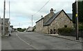
3
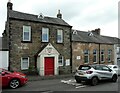
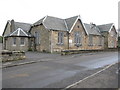
Torrance Community Centre
Originally the village school.
This is an image to replicate Image, the first submitted for this square in 2006.
Image: © Richard Sutcliffe
Taken: 29 Jul 2021
0.05 miles
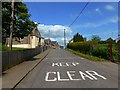
4
Torrance Ornamental & Demonstration Garden
Off Campsie Road in Torrance. It is a small garden area with paths, pond and seats amongst a variety of shrubs. The wooden post with the QR code relates to 'Faces of the Auld Wives’ Lifts' an artwork by Katja Larrson. They comprise of casts of the original faces from a local landmark Image, Image
According to information on line, 'Their placement plays with ideas of archaeological discovery, and being situated discretely at ground level, they invite visitors to stoop down and contemplate their expressions'. Easy if you can find them. I couldn't!
Image: © Richard Sutcliffe
Taken: 8 Mar 2022
0.05 miles
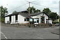
5
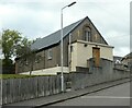
St Dominic's Church, Torrance
Apparently built as a prefabricated timber-framed hall in 1903, by Speirs, Dick and Smith. It was clad in brick and harled in 1959.
Image: © Richard Sutcliffe
Taken: 29 Jul 2021
0.05 miles
6
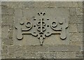
Architectural detail
On the wall of Torrance Community Centre (formerly the village school).
Image: © Richard Sutcliffe
Taken: 29 Jul 2021
0.06 miles
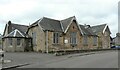
8
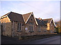
Caldwell Halls
On Campsie Road in Torrance. The two storey part of the halls was built in 1813 as the parochial school and was used as such until the 1870s. The halls are today used as the local community halls, and since December 2010 have been run by the Caldwell Halls Trust.
I do not know the significance of the 1927 date above the door.
Image: © Richard Sutcliffe
Taken: 29 Jul 2021
0.07 miles
9
Torrance Community Centre
On School Road, Torrance.
Image: © G Laird
Taken: 20 Nov 2010
0.07 miles
10
Torrance Parish Church
The church opened in 1999, replacing the original church on the same site, which had been built in 1869 and which had got too small for the large congregation. The new church can accommodate 250 people.
Image: © Richard Sutcliffe
Taken: 29 Jul 2021
0.07 miles