IMAGES TAKEN NEAR TO
Torrance, GLASGOW, G64 4DP
Introduction
This page details the photographs taken nearby to G64 4DP by members of the Geograph project.
The Geograph project started in 2005 with the aim of publishing, organising and preserving representative images for every square kilometre of Great Britain, Ireland and the Isle of Man.

There are currently over 7.5m images from over14,400 individuals and you can help contribute to the project by visiting https://www.geograph.org.uk
Image Map
Images are licensed for reuse under creativecommons.org/licenses/by-sa/2.0
Notes
- Clicking on the map will re-center to the selected point.
- The higher the marker number, the further away the image location is from the centre of the postcode.
Image Listing (20 Images Found)
Images are licensed for reuse under creativecommons.org/licenses/by-sa/2.0
Image
Details
Distance
1
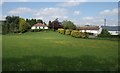
Barraston Nursery
The bungalow is the also the office for the nursery.
Image: © Richard Sutcliffe
Taken: 28 May 2016
0.02 miles
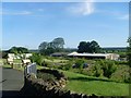
2

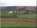
Barraston Nursery
A small plant nursery near Torrance. The glasshouses have seen better days, although still in use, but the chimney for the heating system no longer appears to be used.
Image: © Richard Sutcliffe
Taken: 28 May 2016
0.04 miles
3
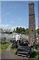
Barraston Nursery
The chimney was used for the heating system for the glasshouses in the past, but no longer appears to be used.
Image: © Richard Sutcliffe
Taken: 28 May 2016
0.04 miles
5
Barraston Holdings
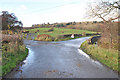
From Barraston Road.
Image: © Richard Sutcliffe
Taken: 28 May 2016
0.13 miles
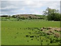
7
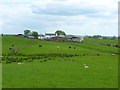
Hillhead Farm
Most of the farm is in the square to the south with just a part in this one.
Image: © Robert Murray
Taken: 31 May 2014
0.15 miles
8
Hillhead Farm
Viewed from near to Back o' Hill.
Image: © G Laird
Taken: 29 Dec 2013
0.16 miles
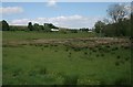
10
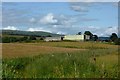
Barraston Holdings
Farmland to the north of Torrance, East Dunbartonshire.
Image: © Stephen Sweeney
Taken: 17 Jun 2010
0.17 miles